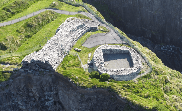
Dún Beag Fort is one of the most important archaeological sites on Slea Head Drive, standing on a narrow Atlantic promontory in Fahan on the southern side of the Dingle Peninsula. Its position immediately tells you why this place matters: the fort was deliberately built where steep coastal ground could become part of its defensive system.
The Ancient Promontory Fort on Slea Head Drive
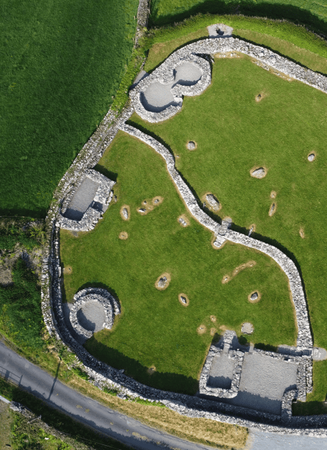
Known officially as An Dún Beag, meaning the small fort, the monument belongs to a much larger archaeological landscape around Fahan. Stone enclosures, clocháns, old field systems and defensive sites survive across the slopes beneath Mount Eagle, demonstrating that this part of the Dingle Peninsula supported organised settlement over a very long period.
Dún Beag is particularly valuable because archaeological excavation has revealed much more than a substantial stone wall. Beneath and around the surviving fort are banks, defensive ditches, an entrance passage, chambers, a souterrain and evidence of occupation within the enclosed promontory.
The fort is also a site under direct pressure from the Atlantic. Coastal erosion has already removed significant portions of the monument, which means the Dún Beag visible today is smaller than the structure recorded by nineteenth-century observers.
If you are planning a visit, my permanent Dún Beag Promontory Fort visitor guide provides the essential site information. This article looks more closely at the fort’s archaeology, defensive design and what the surviving evidence tells us about life on the western peninsula.
Where Is Dún Beag Fort?
Dún Beag lies in Fahan townland on the southern coast of the Dingle Peninsula, west of Ventry and before the road reaches the most exposed western section of Slea Head.
The fort projects towards Dingle Bay from a cliff-edge promontory. Looking south and east, the wider coastal landscape extends towards the Iveragh Peninsula, while immediately inland the slopes of Mount Eagle rise above Fahan.
This setting places Dún Beag close to the remarkable collection of Fahan Clocháns, commonly known as the Beehive Huts. Together, these monuments make Fahan one of the most archaeologically interesting parts of the Slea Head route.
What Is a Promontory Fort?
A promontory fort uses natural geography as part of its defensive design.
Rather than constructing a defensive boundary around every side of a settlement, builders could choose a coastal headland where cliffs already protected several approaches. Artificial banks, ditches and stone ramparts then defended the accessible landward side.
Dún Beag is a particularly clear example. The Atlantic cliffs protect the seaward edges, while an elaborate series of defences crosses the neck of the promontory.
This does not mean we should imagine the fort simply as a battlefield. Defended settlements could also be places where people lived, worked, stored food and managed livestock. The archaeology found inside Dún Beag shows that human occupation formed an important part of its story.
The Defences of Dún Beag
Archaeological excavation revealed a complex defensive system.
The landward approach contained four lines of banks and five fosses, or defensive ditches, before the substantial inner stone rampart was reached.
The surviving inner rampart extends across the promontory and was built from dry stone. At its strongest points, the wall reached more than six metres in thickness and over three metres in height.
That scale is worth considering when you look at the surrounding countryside. Constructing a wall of this size required enormous quantities of stone, organised labour and a detailed understanding of how dry-stone masonry behaves.
The fort was therefore not the result of a small household casually building a boundary. It represents a major investment in creating a protected enclosure.
The Entrance Passage
Access into Dún Beag was tightly controlled through a central causeway and a substantial entrance passage through the stone rampart.
The entrance was originally around two metres wide and more than two metres high, with slightly corbelled side walls and large stone lintels overhead.
Two small chambers were constructed inside the thickness of the rampart on either side of the entrance.
These chambers are particularly interesting because the entrance also contained evidence for a wooden door secured by a substantial bar. Bolt holes allowed the doorway to be controlled from inside the fort.
What appears today as an archaeological passage was therefore once a carefully designed point of access where movement into the enclosure could be controlled.
Was Dún Beag Rebuilt?
Yes. The surviving evidence indicates that the fort developed through more than one construction phase.
The inner section of the main rampart appears to represent an earlier phase, while additional strengthening was subsequently added to the outer side.
The entrance was also modified. At one stage the passage was extended outwards and became narrower and lower, and a new set of bar holes was introduced for another door.
The adjacent defensive ditch was deepened, while material removed from it was incorporated into strengthening work against the rampart.
This tells us something important: Dún Beag was not necessarily built once and then left unchanged. The people using it altered the defences in response to changing needs.
The Souterrain
One of Dún Beag’s most fascinating features lies below ground.
A dry-stone souterrain extends beneath the entrance area for more than sixteen metres. Souterrains are underground passages or chambers found at many early medieval settlement sites in Ireland.
Their exact functions could vary. Archaeologists commonly interpret them as places used for storage and sometimes as refuges during periods of danger.
The presence of the souterrain reinforces the idea that Dún Beag should not be understood merely as a defensive wall. It was part of a functioning settlement landscape with spaces designed for everyday practical needs.
The Clochán Inside the Fort
Excavation also identified a substantial clochán within the interior.
Clocháns are dry-stone structures found widely across the western peninsula and elsewhere along Ireland’s Atlantic coast. Visitors often know them by the descriptive name beehive huts because of the corbelled shape seen in many surviving examples.
The Dún Beag structure was circular externally but had a more rectangular interior. Archaeological evidence suggested more than one phase of occupation.
Hearths and occupation debris provided direct evidence for people living or working inside the enclosure. Animal remains included sheep, goats, pigs and cattle during one phase, while later deposits also contained bird, fish and deer remains.
These discoveries transform Dún Beag from an abstract fortification into a place where people cooked, ate and carried out everyday activities.
The Fahan Clocháns
The clochán at Dún Beag belongs within the wider dry-stone landscape of Fahan.
Nearby Beehive Huts include surviving clocháns and stone enclosures spread across the slopes above the Atlantic.
The exact dates of individual structures are not always secure, and it is important not to describe every clochán as belonging to one single historical period.
What the monuments collectively demonstrate is a long tradition of building with local stone and adapting architecture to an exposed rural landscape.
If archaeology interests you, I would experience Dún Beag and the Fahan sites together rather than seeing them as unrelated roadside attractions.
When Was Dún Beag Built?
Dún Beag does not have one simple construction date.
Excavation carried out by the Office of Public Works in 1977, led by Professor Terry Barry of Trinity College Dublin, demonstrated a complicated sequence of occupation and rebuilding.
The archaeological evidence shows that the site changed through time, but assigning every surviving part of the fort to one precise century would give a false impression of certainty.
That is common with archaeological landscapes of this kind. A strategic site may be occupied, modified, abandoned and reused over long periods.
For the visitor, the important point is that the fort preserves evidence of multiple phases rather than representing one perfectly preserved moment in ancient Ireland.
The 1977 Archaeological Excavation
The 1977 excavation was particularly important because Dún Beag was already being damaged by coastal erosion.
Archaeologists wanted to record the monument and understand its chronology before further portions disappeared into the sea.
The excavation documented the banks and ditches, examined the rampart and entrance, investigated the souterrain and studied the occupation deposits inside the fort.
This work is the reason we know so much about Dún Beag’s internal structure today.
It also demonstrates one of the important roles of archaeology: sometimes excavation is not undertaken because a site is being developed, but because nature itself is destroying the surviving evidence.
The Atlantic Is Still Changing Dún Beag
Coastal erosion is central to the modern story of the fort.
Nineteenth-century records show that Dún Beag once extended substantially further west than it does today. A significant part of the original rampart has already collapsed as the cliff edge retreated.
The Office of Public Works continues to manage the monument as a protected National Monument, but no conservation programme can stop the Atlantic coastline from behaving like an Atlantic coastline indefinitely.
This is one reason direct access to the fort itself is currently prohibited.
Visitors must remain behind the protective barriers and view the monument from the designated fenced walkway. The restriction is not there to reduce the experience; it reflects the genuine instability of a cliff-edge archaeological site.
Can You Enter Dún Beag Fort?
No. Current Office of Public Works guidance states that direct access to the fort is strictly prohibited because of its position close to the eroding cliff edge.
A fenced walkway provides a safe viewing route around the monument.
Do not cross barriers or approach the cliff edge in an attempt to get a better photograph. Parts of the coast can be unstable even where the ground appears secure.
This is particularly important after storms and prolonged periods of wet weather, when erosion and ground conditions may have changed since previous photographs or online visitor reports were published.
What Can You See from the Viewing Area?
Although visitors cannot now enter the fort itself, the viewing area still allows you to understand the essential structure and setting.
You can see the heavy stone rampart crossing the promontory and appreciate how the monument uses the cliff edge as part of its defensive position.
The surrounding Atlantic landscape is equally important. Looking beyond the monument helps explain why this headland was chosen in the first place.
I would spend a few minutes looking at the geography before concentrating on the stonework. The fort makes much more sense when you see the cliffs, headland and landward approach together.
Dún Beag and Slea Head Drive
Dún Beag is naturally experienced as part of a larger journey around Slea Head Drive.
Leaving Dingle, the road passes through Ventry before reaching Fahan. Beyond Dún Beag, the coastline becomes increasingly exposed as the route continues towards Coumeenoole and the western end of the peninsula.
This sequence is important because the archaeological landscape gradually gives way to some of West Kerry’s strongest Atlantic scenery.
If you are driving independently, my broader guide to experiencing Slea Head in one day can help you decide how much time to allocate to archaeology versus viewpoints and coastal stops.
Coumeenoole Beach
Continue west from Fahan and one of the next major landscapes is Coumeenoole Beach.
The contrast with Dún Beag is useful. At the fort, you are examining how people adapted a cliff-edge landscape for defence and settlement. At Coumeenoole, the Atlantic itself becomes the dominant feature.
The beach lies beneath steep coastal slopes with the Blasket Islands offshore, giving visitors one of the clearest visual demonstrations of how exposed the western Dingle Peninsula is.
Dún Chaoin and Dunquin Pier
Further around the route, Dunquin Pier brings another aspect of West Kerry history into the journey.
Here the focus shifts from archaeological settlement to the maritime relationship between Dún Chaoin and the Blasket Islands.
That is what makes Slea Head such an interesting route historically. Within a relatively short distance, you move from ancient fortifications and clocháns to early Christian monuments, Gaeltacht communities and the modern history of island life.
Dún Beag and the Wider History of the Peninsula
The Dingle Peninsula contains an unusually dense concentration of archaeological monuments.
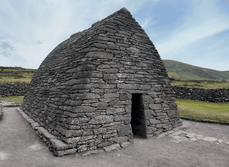
Further around the western peninsula, Gallarus Oratory represents a very different phase of religious and architectural history, while Kilmalkedar Church preserves medieval architecture alongside earlier inscribed stones and pilgrimage traditions.
Riasc Monastic Settlement provides another contrast, revealing evidence for an early medieval ecclesiastical community.
Together, these places show why the peninsula should never be reduced to scenery alone.
Dry-Stone Building in West Kerry
Dún Beag also belongs to a much broader tradition of stone construction.
Stone is everywhere on the western peninsula: field boundaries, clocháns, cashels, churches and defensive walls were all shaped by the availability of local material.
The building techniques vary considerably. A corbelled clochán is not constructed in the same way as a massive defensive rampart, and a medieval church such as Gallarus belongs to another architectural context again.
But collectively they demonstrate generations of skill in working with local stone in an environment where timber and other construction materials could be less readily available.
What Dún Beag Tells Us About Everyday Life
The most interesting archaeological evidence is sometimes the least visually dramatic.
Animal bones, hearths and post or stake holes do not create the same immediate impact as a massive stone rampart.
Yet those smaller finds tell us more directly about people.
They show food being cooked, animals being consumed and structures being created within the enclosure. They remind us that Dún Beag was not built simply so future generations could admire its defensive architecture.
People actually lived and worked here.
What Visitors Commonly Miss
Most visitors naturally look first at the large stone wall.
I would also pay attention to the layers in front of it.
The banks and ditches on the landward side formed an important part of the defence. The entrance controlled movement into the site. The souterrain added underground space. The clochán represented occupation within the enclosure.
Once you understand these elements, Dún Beag becomes a defensive system and settlement rather than simply a wall beside the sea.
Visiting Dún Beag Today
Dún Beag is a state-owned National Monument in the care of the Office of Public Works.
The fort itself cannot currently be entered. Visitors must remain on the designated fenced viewing route because of the unstable cliff-edge position and continuing coastal erosion.
The site is unguided, so normal care is required when walking in exposed coastal conditions.
Current access conditions should always take priority over older guidebooks, photographs or online reviews. Coastal archaeological sites can change after storms and erosion events.
How Long Should You Allow?
For most visitors following Slea Head Drive, around 20 to 30 minutes is a reasonable amount of time to understand the monument and its setting from the current viewing area.
History and archaeology enthusiasts may want longer, particularly if they are also examining the wider Fahan landscape.
The important thing is not to judge the value of the stop according to how much walking is involved. Much of Dún Beag’s significance comes from understanding what once existed here and how the surviving features fit together.
Weather at Dún Beag
The site is directly exposed to Atlantic conditions.
Wind can be considerably stronger on the promontory than it was in Dingle or Ventry, and rain can make walking surfaces wet and less comfortable.
A waterproof layer is sensible even when conditions look settled at the beginning of the day.
The exposed weather also forms part of the story. The same Atlantic environment visitors experience today is one of the forces gradually removing the archaeological site itself.
Photography at Dún Beag
Because direct access is prohibited, photography should be undertaken entirely from the designated safe viewing areas.
The strongest photographs often include the surrounding coastline rather than concentrating only on the rampart.
A wider composition helps show the fort’s relationship with the cliff edge and demonstrates why this particular promontory was defensively useful.
Never cross a barrier or move towards an unstable edge for a different angle. No photograph is worth ignoring the conditions that have already caused substantial parts of Dún Beag to disappear into the sea.
Who Will Enjoy Dún Beag Most?
Dún Beag is particularly rewarding for visitors interested in archaeology, ancient settlement, defensive architecture and the way people adapted to the Kerry landscape.
It also works well for families with older children when the site is explained properly, because the defensive system provides an accessible way to discuss how ancient communities protected themselves.
Visitors primarily interested in scenery will still appreciate the coastal setting, but understanding even a little of the archaeology makes the stop much more valuable.
Seeing Dún Beag with a Local Guide
Dún Beag is exactly the kind of place where interpretation matters.
Without context, you may see a stone wall on a dramatic headland. Once the banks, ditches, entrance chambers, souterrain, occupation evidence and erosion history are explained, the site becomes considerably richer.
It can be incorporated naturally into my private Dingle Peninsula half-day tour, where the archaeology of Fahan can be connected with the Atlantic landscapes and other historic sites encountered around the western peninsula.
That wider context is important. Dún Beag was never an isolated monument, and it should not be experienced as one today.
Continue Exploring West Kerry
Dún Beag is one of the strongest places to begin exploring the archaeology of the western Dingle Peninsula.
Nearby Fahan Clocháns reveal another aspect of dry-stone settlement, while further around the peninsula Gallarus Oratory, Kilmalkedar Church and Riasc demonstrate the development of religious communities and medieval architecture.
Visitors who want to explore more of Kerry’s past can use the Historical Sites in Kerry collection, while the main Explore Kerry guide connects those monuments with beaches, towns, scenic drives and natural landscapes across the county.
Dún Beag is ultimately a powerful reminder that archaeology is not permanent. The fort was constructed to use the coastline as part of its strength, yet that same coastline is gradually destroying it. Looking across the surviving rampart towards the Atlantic, you are seeing both an ancient defensive landscape and an archaeological site that continues to change.
Frequently Asked Questions About Dún Beag Fort
What is Dún Beag Fort?
Dún Beag is a coastal promontory fort at Fahan on the Dingle Peninsula. Its defensive system includes banks, ditches and a substantial dry-stone rampart protecting a naturally defended cliff-edge promontory.
Where is Dún Beag Fort?
The fort lies at Fahan on Slea Head Drive, west of Ventry on the southern side of the Dingle Peninsula in County Kerry.
How old is Dún Beag?
The fort developed through multiple phases of construction and occupation rather than belonging neatly to one securely established date. Archaeological excavation has demonstrated rebuilding and more than one phase of human activity at the site.
Can you enter Dún Beag Fort?
No. Current Office of Public Works guidance prohibits direct access because the monument stands close to an unstable, eroding cliff edge. Visitors must view the fort from the designated fenced walkway.
Why is Dún Beag falling into the sea?
The fort was constructed on an exposed Atlantic promontory. Natural coastal erosion and storm damage have progressively removed sections of the cliff and monument, and nineteenth-century records show that the fort was once considerably larger than what survives today.
Was there a house inside Dún Beag?
Excavation identified a substantial clochán within the enclosure. Hearths, animal remains and other occupation evidence demonstrate that people lived or carried out domestic activities inside the fort.
What is the underground passage at Dún Beag?
A dry-stone souterrain extends beneath part of the fort’s entrance area. Souterrains are underground structures commonly associated with early medieval settlement sites and are generally interpreted as having uses including storage and refuge.
How long should I spend at Dún Beag?
Around 20 to 30 minutes is sufficient for many visitors using the current viewing route. Archaeology enthusiasts may want longer, especially if combining the fort with other Fahan sites.
What other historical sites are near Dún Beag?
The Fahan Clocháns are very close, while Gallarus Oratory, Kilmalkedar Church and Riasc Monastic Settlement can all be incorporated into a broader historical journey around the western Dingle Peninsula.
Is Dún Beag Fort worth visiting?
Yes, particularly if you are interested in archaeology or the history behind Slea Head. Its defensive architecture, evidence of occupation and continuing battle with coastal erosion make Dún Beag one of the most informative archaeological sites on the Dingle Peninsula.