
HISTORY COLLECTION
Perched on a rocky headland overlooking Dingle Bay, Dún Beag is one of County Kerry’s most significant coastal promontory forts.
First Millennium BC to
Early Medieval Period
Fahan Townland
County Kerry
Coastal
Promontory Fort
View from Designated
Fenced Path Only
Dún Beag occupies a narrow rocky promontory overlooking Dingle Bay, where its surviving defences remain visible despite centuries of coastal erosion. The monument includes a massive drystone rampart, a controlled entrance, an underground souterrain and the remains of a substantial clochán within the enclosure. Together, these features illustrate how the site developed over several phases between prehistoric activity and the early medieval period. Visitors can appreciate the monument from the designated viewing route while helping to protect this fragile archaeological landscape.
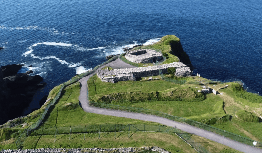
The surviving drystone rampart formed the monument’s principal landward defence.
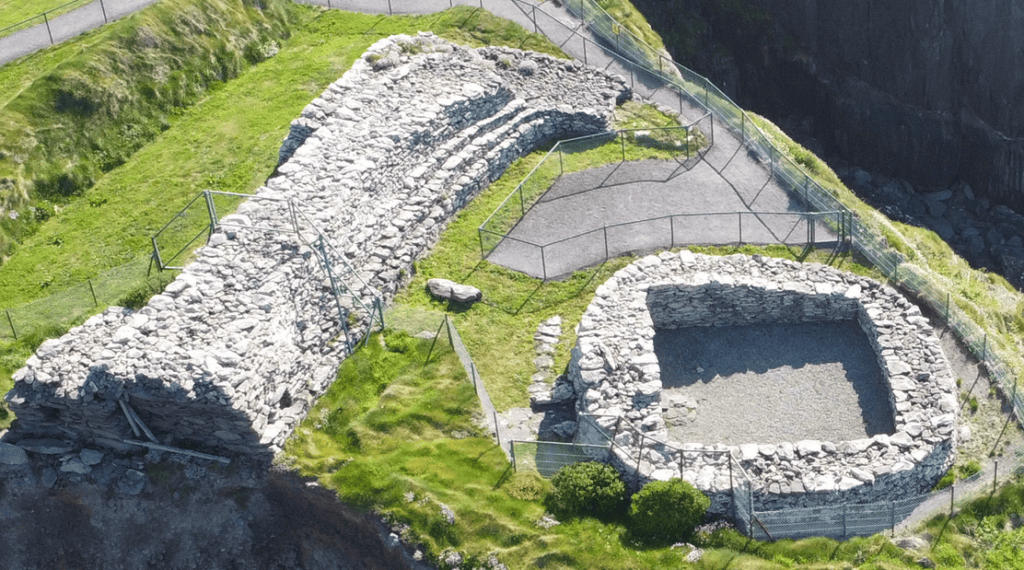
The clochán preserves evidence of occupation during the early medieval period.
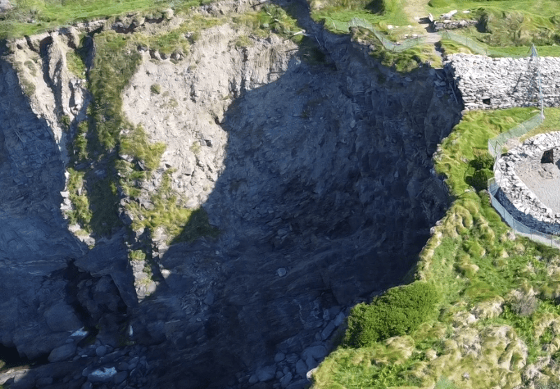
Coastal erosion continues to reshape and threaten the surviving monument.
Dún Beag is a protected National Monument located on the southern coast of the Dingle Peninsula. Archaeological excavation has shown that the monument developed through several phases between prehistoric activity and the early medieval period. Although its builders remain unknown, its surviving drystone defences, underground souterrain and internal clochán make it one of County Kerry’s most important coastal archaeological sites.
Irish name
An Dún Beag
County
Kerry
Monument Type
Coastal promontory fort
National Monument Number
177
Historical Period
Prehistoric and Early Medieval.
Ownership
State-owned
Date
First millennium BC–Early Medieval
Condition
Actively affected by coastal erosion
Townland
Fahan (Fán)
Archaeological Investigation
Excavated (1977); further archaeological work (2018)
Civil Parish
Ballinvoher (Baile an Bhóthair)
Public Access
Free OPW access
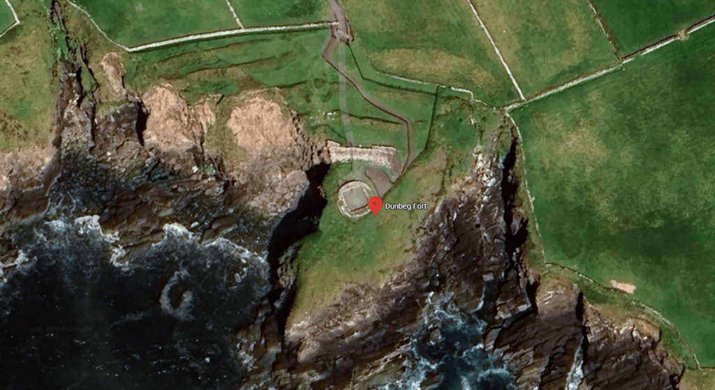
Latitude
52.103453
Longitude
-10.408063
Address
Carhoo, Co. Kerry
Nearest Town
Ventry
Road access
R559
Dún Beag developed over several distinct phases rather than being built during a single period. Archaeological evidence shows that activity on the rocky promontory began during the first millennium BC, when a charcoal sample associated with a possible burnt wattle feature was dated to approximately 580 ± 35 BC. While this confirms early occupation or activity, it does not prove that the surviving stone fortifications were present at that time.
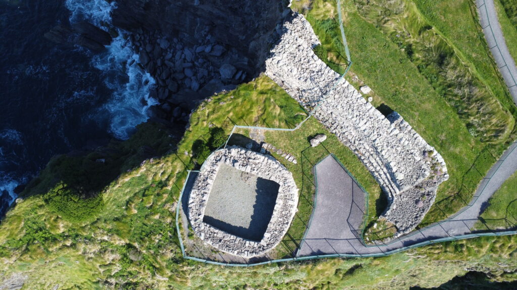
The defensive wall and enclosed area of Dunbeg Fort.
During the early medieval period, the monument was substantially modified or rebuilt. Excavation identified several phases of defensive construction, including multiple banks and fosses, a massive drystone rampart, a controlled entrance passage, wall chambers and an underground souterrain. Radiocarbon evidence associated with the defensive sequence indicates activity during approximately the eighth or ninth century AD, demonstrating that the fort continued to evolve long after its earliest occupation.
Within the enclosure stood a substantial drystone clochán, where archaeologists identified at least two occupation phases dating broadly to the tenth and eleventh centuries AD. Hearths, stake-holes and animal bone assemblages indicate episodes of domestic activity, although the available evidence suggests that occupation may have been intermittent rather than continuous. No historical records identify who built or occupied Dún Beag, and its precise social role remains uncertain.
Although the monument clearly served a defensive purpose, archaeologists have proposed several possible functions. These include a defended residence, a community refuge, a high-status enclosed settlement, a seasonal occupation site or a local stronghold controlling movement along the coast. The available evidence supports these as archaeological interpretations rather than established facts, and no single explanation has been conclusively demonstrated.
Following the early medieval period, regular occupation appears to have declined, although the exact date of abandonment is unknown. Over the following centuries the monument experienced restoration, continued coastal erosion and increasing archaeological investigation. Major cliff collapses during 2014 and again between 2017 and 2018 destroyed significant sections of the surviving monument, making Dún Beag one of Ireland’s best-known examples of an archaeological site undergoing active coastal erosion. Today it is protected as a National Monument and managed through ongoing conservation, digital recording and controlled visitor access.
One of the most common misconceptions is that Dún Beag was built around 580 BC. The excavation evidence does not support this conclusion. The radiocarbon date relates to charcoal from an early feature beneath or preceding the later stone defences, while the surviving monument developed through multiple phases extending into the early medieval period.
Dún Beag was constructed on a naturally defensive rocky headland overlooking Dingle Bay. Rather than enclosing a large area, its builders concentrated their efforts across the narrow landward approach, where they created a layered defensive system that worked with the surrounding sea cliffs. This combination of natural and artificial defences is characteristic of a coastal promontory fort.
Excavation identified four earthen banks and five fosses cut across the neck of the promontory. A narrow stone-lined causeway led visitors through these outer defences towards a substantial drystone rampart measuring approximately 29 metres in length, up to 6.35 metres thick and over 3 metres high in places. Archaeological evidence shows that the rampart itself underwent at least two principal phases of construction and strengthening.
The entrance was carefully engineered to control access. An earlier wider gateway was later narrowed, extended and lowered so that anyone entering was forced into single file. Door-bar holes, stone rebates and evidence for timber locking arrangements demonstrate that the entrance could be securely closed when required. Two chambers built within the thickness of the rampart overlooked the gateway, although their precise function remains uncertain.
Beneath the entrance approach lay a drystone souterrain extending for approximately 16.5 metres beneath the causeway and outer defences. Although its exact purpose cannot be determined with certainty, archaeologists suggest that it may have served as concealed storage, temporary refuge or a secure place for valuables. There is no authoritative evidence that it functioned as a secret escape tunnel to the sea.
Within the enclosure stood a substantial drystone clochán, built using carefully laid local stone without mortar. The surviving structure is roughly circular externally with a rectangular interior and retains evidence of a lintelled doorway fitted with door supports and draw-bar holes. Because of its unusually large span, archaeologists question whether it ever supported a complete corbelled stone roof, suggesting that lighter roofing methods may have been used instead.
The strength of Dún Beag did not depend on high walls alone. Its builders combined natural sea cliffs with banks, fosses, a narrow entrance, heavy drystone construction and secure timber door fittings to create a layered defensive system that controlled movement through the monument.
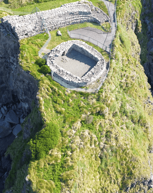
The surviving defensive wall demonstrates the strength and precision of Dún Beag’s drystone construction.
Much of what is known about Dún Beag comes from archaeological excavation rather than written history. The principal investigation was carried out between June and September 1977 under Professor Terence B. Barry of Trinity College Dublin. The excavation was undertaken because ongoing coastal erosion threatened the survival of the monument, providing an opportunity to investigate its construction, occupation and development before further losses occurred.
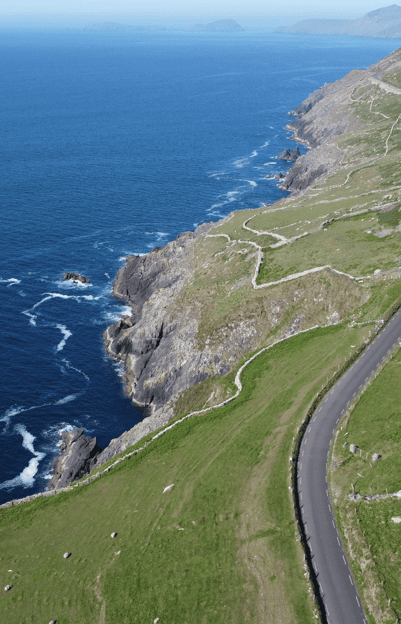
Dún Beag Coastal Landscape
The excavation revealed that Dún Beag was built and modified over several distinct phases. Archaeologists uncovered four defensive banks, five fosses, a massive drystone rampart, a controlled entrance, two chambers built within the rampart, an underground souterrain and the remains of a substantial clochán. Careful examination of these structures demonstrated that the monument was repeatedly altered rather than constructed during a single building episode.
Radiocarbon dating provided important evidence for the monument’s chronology. The earliest sample, obtained from charcoal associated with a possible burnt wattle feature, produced a date centred on approximately 580 BC. Later samples associated with the defensive sequence suggest activity during the eighth or ninth century AD, while two occupation layers within the clochán indicate use during the tenth and eleventh centuries AD. Together, these results demonstrate that Dún Beag was occupied and modified across many centuries.
Evidence for daily life came from hearths, stake-holes and animal bone assemblages recovered during excavation. The faunal remains included sheep or goat, pig, cattle, deer, bird and fish, indicating a varied diet. Although relatively few artefacts have been published, the archaeological evidence provides valuable insight into how the monument was used, even where written records are absent.
Following major storm damage in 2014 and again between 2017 and 2018, further archaeological work was carried out under consultant archaeologist Laurence Dunne. More recently, digital technologies including drone photography, photogrammetry, laser scanning and three-dimensional modelling have been used to record the monument as coastal erosion continues to threaten its survival. These surveys preserve detailed information even where parts of the archaeological fabric have already been lost.
Archaeology has shown that Dún Beag cannot be assigned a single construction date. Instead, excavation and radiocarbon dating demonstrate a complex sequence of prehistoric activity, early medieval rebuilding and later occupation spanning many centuries.
Although no written records describe daily life at Dún Beag, archaeological excavation provides valuable evidence for how the monument was used. Within the interior clochán, archaeologists identified at least two separate occupation phases associated with hearths, stake-holes and domestic deposits. These remains show that people lived within the enclosure during different periods rather than throughout its entire history.
Animal bone recovered during excavation indicates that the occupants consumed a varied diet. The earliest occupation deposits contained the remains of sheep or goat, pig and some cattle, while later deposits also included deer, bird and fish. These finds suggest that farming, hunting and the exploitation of coastal resources all contributed to daily life, although the available evidence cannot determine the relative importance of each activity.
The clochán contained small hearths used for cooking and heating, while clusters of stake-holes may have supported cooking equipment or lightweight internal structures. Together, these features demonstrate that the building functioned as a practical living space during at least part of its occupation, even though its original roof construction remains uncertain.
The archaeological evidence suggests that occupation may have been intermittent rather than permanent. The relatively limited domestic deposits and the exposed coastal location support the possibility that Dún Beag was used during particular seasons, periods of heightened insecurity or for specific social and defensive purposes. These remain archaeological interpretations rather than established facts.
Life within Dún Beag would have been shaped by its dramatic coastal setting. While the surrounding cliffs provided excellent natural protection and extensive views across Dingle Bay, they also exposed the occupants to strong Atlantic winds, limited living space and uncertain access to freshwater. These conditions may help explain why the monument appears to have been occupied in phases rather than continuously.
The archaeological evidence confirms that people lived at Dún Beag during different periods, but it does not prove that the monument was occupied continuously. Current evidence points instead towards episodes of habitation separated by periods of rebuilding or reuse.
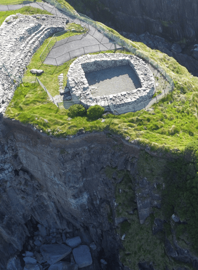
Dún Beag Cliff Edge Clochán
Dún Beag occupies a narrow rocky promontory projecting into Dingle Bay on the southern coast of the Dingle Peninsula. Steep sea cliffs protect much of the site naturally, leaving only the narrow landward approach vulnerable. This setting allowed the builders to concentrate their defensive works across the neck of the headland while relying on the surrounding landscape as a formidable natural barrier.
Dún Beag Stone Fort Defences
From its elevated position, the monument commands extensive views across Dingle Bay and along the surrounding coastline. These long sightlines would have allowed the occupants to observe movement by sea and across the coastal landscape. While this strategic location offered important defensive advantages, there is no evidence that Dún Beag functioned as a harbour fort or customs station.
The dramatic coastal setting also presented significant challenges. Strong Atlantic winds, exposure to severe weather, limited space for settlement and uncertain freshwater supplies would have made long-term occupation difficult. These environmental factors support the archaeological interpretation that the monument may have been occupied intermittently rather than continuously.
Dún Beag forms part of a wider archaeological landscape in the Fahan townland, where numerous clocháns, cashels, enclosed farmsteads, souterrains, field systems and early ecclesiastical sites survive. Together these monuments demonstrate that the surrounding area supported a long-lived and complex human landscape, although the precise relationship between individual sites has not yet been fully established through excavation and dating.
Today, the landscape continues to shape the monument’s future. Coastal erosion has been documented since the nineteenth century, and major cliff collapses in recent years have destroyed significant archaeological remains. Current conservation focuses on managed retreat, digital recording and public safety rather than attempting to halt the natural processes affecting the coastline.
The sea cliffs that once made Dún Beag an exceptionally strong defensive position are now its greatest threat. Natural coastal erosion continues to remove parts of the archaeological site despite ongoing conservation and digital recording.
Follow the story of Dún Beag from the earliest evidence of activity on the promontory through the development of its defences, early medieval occupation, archaeological investigation and modern conservation. Its surviving remains reveal a complex history of construction, rebuilding and reuse extending across many centuries.
Charcoal associated with a possible burnt wattle feature provides the earliest evidence of activity on the promontory. This date does not establish the construction of the surviving stone fort.
The headland was used during the first millennium BC, possibly as an early enclosure or defended site before later rebuilding.
The defensive system was constructed, reused or substantially modified, creating the impressive drystone monument visible today.
Radiocarbon evidence associated with the defensive sequence indicates continued activity during the early medieval period.
The first recognised occupation phase within the internal stone-built clochán dates to around the tenth century AD.
A second occupation phase confirms continued use of the clochán during the tenth and eleventh centuries.
George Victor Du Noyer recorded the monument, preserving valuable evidence of features that have since been lost.
Restoration altered parts of the monument, and some surviving masonry may include reconstructed sections.
Professor Terence B. Barry directed the first major archaeological excavation, revealing the monument’s complex development.
Barry’s excavation report was published, becoming the principal archaeological reference for Dún Beag.
A severe Atlantic storm caused significant cliff collapse and the loss of important archaeological remains.
Additional storm damage destroyed significant archaeological fabric, including part of the entrance complex.
Everything you need to know before visiting Dunbeg Fort, including parking, access, admission, facilities and practical information to help you make the most of your visit.
Fahan Townland, Dingle Peninsula, County Kerry, Ireland. Dún Beag stands on the southern coast overlooking Dingle Bay along the Slea Head route.
Visitor parking is available near the entrance. From the parking area, the monument is reached by a short walk.
The monument is viewed from the designated fenced viewing route. Visitors should remain within the permitted access area because of coastal erosion and unstable cliff conditions.
An admission charge may apply. Opening arrangements and access conditions can change, so visitors should check the latest information before travelling.
Early morning and late afternoon generally offer quieter conditions, softer light and excellent views across the Atlantic coast.
Nearby heritage stops include the Fahan beehive huts, Gallarus Oratory, Kilmalkedar Church and Riasc Monastic Site.
Explore more historic places, monuments and archaeological sites across County Kerry.
Reading about Dunbeg Fort is only the beginning. Experience its dramatic coastal setting, discover the archaeological evidence in context and hear the stories that bring this remarkable monument to life on a private guided tour of the Dingle Peninsula.
If you would rather leave the driving behind, I offer private tours across the Dingle Peninsula and County Kerry. Each experience is designed for small private groups, with a relaxed pace, local knowledge and the flexibility to spend more time at the places that interest you most.
A relaxed three-hour private tour around Slea Head and the spectacular western coastline of the Dingle Peninsula.
Explore Slea Head, ancient heritage sites, coastal viewpoints and the landscapes of West Kerry on a private half-day experience.
Discover more of the Dingle Peninsula with a full day to explore its scenery, history, villages and lesser-known places.
Journey around the Iveragh Peninsula, combining the Ring of Kerry with the dramatic landscapes and Atlantic coastline of the Skellig Ring.
Explore Killarney National Park, its lakes, mountain viewpoints, waterfalls and some of the most beautiful landscapes in County Kerry.
Travel north from Kerry for a private day tour through the Burren to the spectacular Cliffs of Moher on Ireland’s Atlantic coast.
Create a private Kerry itinerary around the places, landscapes and experiences that matter most to you.
Archaeological excavation, radiocarbon dating, historic surveys and modern digital recording have all contributed to our understanding of Dún Beag. The principal sources below document the monument’s construction, occupation, changing condition and continuing vulnerability to coastal erosion.
Office of Public Works (Heritage Ireland) – Dún Beag.
National Monuments Service – Record of Monuments and Places (KE052-270).
Placenames Database of Ireland – An Dún Beag.
McCormick, Fergus & Nicolas, Melissa (2022). Impacts of Climate Change on Coastal Archaeological Sites in County Kerry, Ireland. Internet Archaeology.
The Discovery Programme – CHERISH (Climate, Heritage and Environments of Reefs, Islands and Headlands).
Harbison, Peter. Guide to the National and Historic Monuments of Ireland (1992).
Cuppage, Judith. Archaeological Survey of the Dingle Peninsula (1986).
Barry, Terence B. Archaeological Excavations at Dunbeg Promontory Fort, County Kerry, 1977. Proceedings of the Royal Irish Academy, Section C, Vol. 81 (1981).
Loading availability…