Dingle to the Cliffs of Moher: Route, Ferry, Stops and Travel Time
Dingle to the Cliffs of Moher is one of the most rewarding full-day journeys you can make from the Dingle Peninsula. The route carries you east through County Kerry, north across the Shannon Estuary by car ferry and onwards through the coastal landscape of West Clare. The cliffs are the main destination, but the ferry crossing, estuary views, traditional towns and changing geology make the journey far more than a simple drive between two attractions.
This is also a substantial day on the road. The journey normally takes approximately three to three and a half hours in each direction, depending on traffic, ferry connections and the route chosen through Clare. Once time at the cliffs, lunch and additional stops are included, a comfortable outing can easily last nine to eleven hours.
Whenever I bring visitors from Dingle to the Cliffs of Moher, I treat the travelling itself as part of the experience. Kerry’s mountains gradually give way to the Shannon Estuary, the ferry provides a natural break from driving, and the landscape changes again as you approach the exposed Atlantic coast of County Clare. With realistic timing and carefully chosen stops, it becomes one of the most varied touring days available from Dingle.
Can You Visit the Cliffs of Moher from Dingle in One Day?
Yes, the Cliffs of Moher can be visited from Dingle as a day trip, but an early start is strongly recommended. This is not a short excursion, and trying to combine too many additional attractions can leave the day feeling rushed.
I would normally suggest leaving Dingle at around 8.00 or 9.00 in the morning. This provides enough time to reach the Tarbert ferry, cross into County Clare, stop for lunch and spend approximately 90 minutes to two hours at the cliffs. Depending on the season, traffic and return ferry, you would generally arrive back in Dingle during the early evening.
The trip is particularly suitable for visitors spending several nights in Dingle who want to see another section of Ireland’s Atlantic coast without changing accommodation. If your time in the area is limited, the guide to how long to spend in Dingle may help you decide whether to dedicate a full day to County Clare.
The Main Route from Dingle to the Cliffs of Moher
The most interesting route runs from Dingle to Tralee, follows the northern Kerry road towards Tarbert, crosses the Shannon Estuary to Killimer and then continues through West Clare to the Cliffs of Moher.
The journey can be understood in five main stages:
- Dingle to Tralee along the N86
- Tralee to Listowel and Tarbert
- Tarbert to Killimer on the Shannon Ferry
- Killimer through Kilrush and West Clare
- Ennistymon or Lahinch to the Cliffs of Moher
Although a navigation app may occasionally suggest a different route based on traffic, the ferry route is usually the most memorable option. It avoids travelling inland through Limerick and turns the crossing of the Shannon into part of the day.
Dingle to Tralee
The first section follows the N86 east from Dingle towards Annascaul, Lispole and Tralee. The road crosses the interior of the peninsula between mountains, farmland and the shores of Tralee Bay. Visitors who have only explored Slea Head Drive will see a different side of the peninsula here: broader valleys, working farms and routes that historically connected West Kerry with the county’s principal market towns.
Tralee is the largest town in County Kerry and an important point on the journey. You do not need to enter the centre unless you want refreshments, but it is a sensible place to pause if necessary before continuing north.
Tralee to Listowel and Tarbert
From Tralee, the route continues north through the agricultural landscape of North Kerry. The scenery is gentler than the western end of the Dingle Peninsula, with rolling farmland, river valleys and small settlements replacing the high sea cliffs and Atlantic headlands.
The road passes through or near Listowel, a town with a strong literary tradition and an attractive historic centre. Listowel is associated with writers including John B. Keane and Bryan MacMahon, and it can be a worthwhile stop if your schedule allows. However, on a return trip to the Cliffs of Moher, I would usually keep the outward stop brief and preserve more time for the coast.
From Listowel, continue towards Tarbert on the N69. Tarbert sits on the southern side of the Shannon Estuary, where the river widens dramatically before meeting the Atlantic. The ferry terminal is located outside the village and is clearly signposted.
Taking the Tarbert to Killimer Ferry
The Shannon Ferry carries vehicles and passengers between Tarbert in County Kerry and Killimer in County Clare. The crossing takes approximately 20 minutes and removes the need to drive inland around the Shannon through Limerick.
For visitors, the ferry is more than a practical shortcut. Once the vehicle is safely parked, passengers can usually step out and enjoy the estuary air and open views. The short crossing also provides a welcome break after the drive from Dingle.
There is sometimes a chance of seeing wildlife in the estuary, including dolphins, but sightings are never guaranteed. The Shannon Estuary is a large and active maritime environment, and visibility depends on weather, light and conditions on the day.
Do You Need to Book the Shannon Ferry?
Drivers can generally purchase a ticket at the terminal, while tickets may also be bought online. Sailing frequency changes according to the month and time of day, so you should always check the current official Shannon Ferries timetable before leaving Dingle.
It is sensible to reach Tarbert at least a few minutes before your intended sailing. In busy periods, especially during summer weekends and public holidays, allow additional time in case you cannot board the first available ferry.
The crossing itself may take only about 20 minutes, but route planning should include time for approaching the terminal, queuing, loading and disembarking. From a touring point of view, I usually allow approximately 40 to 60 minutes for the complete ferry stage rather than calculating only the sailing time.
Killimer to the Cliffs of Moher
After arriving at Killimer, the journey continues through West Clare. The most direct practical route generally passes Kilrush before turning north towards towns such as Miltown Malbay, Lahinch or Ennistymon, depending on current road conditions and your chosen stops.
This section reveals another distinctive Atlantic landscape. The Shannon Estuary gradually gives way to open bogland, farmland and coastal settlements. Traditional music is deeply associated with West Clare, while fishing, farming and emigration have all shaped the communities along the route.
Lahinch is a well-known seaside town with a long beach facing Liscannor Bay. Ennistymon, a short distance inland, is recognised for its traditional streetscape and the cascades on the River Inagh. Either can work as a lunch or refreshment stop, but attempting to explore both properly will reduce your time at the cliffs.
From this area, the final approach leads towards Liscannor and the official Cliffs of Moher Experience. As you travel north, the landscape becomes increasingly influenced by the limestone terrain associated with the Burren and the wider Burren and Cliffs of Moher UNESCO Global Geopark.
How Long Does It Take to Drive from Dingle to the Cliffs of Moher?
Without substantial stops, the journey from Dingle to the Cliffs of Moher via the Shannon Ferry normally requires approximately three to three and a half hours. This estimate includes a reasonably well-timed ferry connection but should not be treated as a guaranteed arrival time.
Your actual travel time can be affected by:
- Traffic between Dingle and Tralee
- Roadworks or slow-moving vehicles
- The ferry timetable and boarding queue
- Seasonal visitor traffic in West Clare
- Weather and visibility
- Stops for food, photographs or facilities
A return journey therefore involves at least six hours of combined driving and ferry travel. Once you add a proper visit to the cliffs and a meal stop, nine hours is a realistic minimum for the full outing. A more relaxed day with additional coastal stops may take ten or eleven hours.
What Will You Experience at the Cliffs of Moher?
The Cliffs of Moher rise from the Atlantic coast of County Clare in a long wall of layered shale and sandstone. They extend for approximately eight kilometres and reach their greatest height of about 214 metres near O’Brien’s Tower.
The rock layers were formed more than 300 million years ago from sediments deposited in an ancient river delta. Over immense periods of time, erosion removed softer material and exposed the vertical cliffs visible today. The alternating bands in the cliff face record changing flows of sand, silt and mud through that ancient environment.
From the official visitor area, paved paths lead towards several viewpoints. Looking south, the cliffs recede towards Hag’s Head. To the north, the coastline continues in the direction of Doolin. On a clear day, views can extend across Galway Bay towards the Aran Islands and the mountains of Connemara.
The experience changes greatly with the weather. On a bright, clear day, the scale and shape of the coastline are immediately visible. In mist, parts of the cliffs may disappear completely. Strong Atlantic winds can also make conditions feel much colder than they did inland.
O’Brien’s Tower
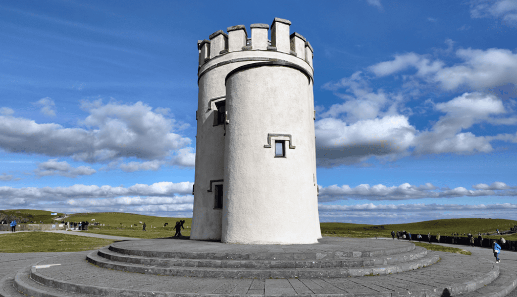
O’Brien’s Tower stands near one of the highest sections of the cliffs. It was built in the nineteenth century by Sir Cornelius O’Brien as a viewing structure for visitors, demonstrating that people were travelling to admire this coastline long before modern tourism developed.
The tower is one of the most recognisable landmarks at the site. Access arrangements can change, so check locally if entering the tower is important to your visit.
The Visitor Centre
The visitor centre is built into the hillside to reduce its visual impact on the surrounding landscape. It contains interpretation about the geology, wildlife, history and maritime environment of the cliffs. There are also toilets, food options and indoor shelter.
This indoor section is particularly useful when showers pass through. However, it should complement rather than replace time outside. The real scale of the cliffs only becomes apparent from the paths and viewing areas.
How Much Time Should You Allow at the Cliffs?
For a day trip from Dingle, I would allow approximately 90 minutes to two hours at the Cliffs of Moher. This gives enough time to visit the main viewpoints, explore the visitor centre and walk a reasonable section of the official paths without rushing.
A shorter visit of about an hour is possible, but it leaves little flexibility for parking, toilets, changing weather or photographs. Visitors who want a longer coastal walk would need considerably more time and should treat that as a separate activity rather than adding it casually to an already long driving day.
The official visitor area includes surfaced routes, but conditions and gradients vary. Paths beyond the central developed area can be more exposed and uneven. Remain on designated routes, follow current safety notices and keep well back from unprotected cliff edges.
Admission, Parking and Practical Information
The main car park is situated across the road from the visitor centre. Admission to the official experience generally includes parking and access to the visitor facilities, but prices and booking arrangements can change.
Advance booking may provide better value and is sensible during busy periods. Before travelling, check the official Cliffs of Moher visitor information for current admission, opening times, parking arrangements and path notices.
Bring a waterproof outer layer even if the weather appears settled in Dingle. Comfortable footwear is advisable, particularly if you plan to walk beyond the nearest viewpoints. Sunglasses can also be useful because glare from the Atlantic may be strong when the sky clears.
Visitors with reduced mobility should review the current accessibility information before travelling. The main visitor centre and principal viewing areas have developed access routes, but gradients, wind and the distance between viewpoints may still influence how much of the site is comfortable to explore.
Weather and Visibility
Weather is the greatest variable on this journey. Dingle, the Shannon Estuary and West Clare can experience different conditions on the same day. Clear skies in Kerry do not guarantee clear views at the cliffs, and poor weather in Dingle may improve considerably by the time you reach Clare.
Low cloud and sea mist can restrict visibility, sometimes concealing the cliffs almost entirely. Strong winds may affect exposed paths and ferry operations, while heavy rain can make walking less comfortable. Always follow instructions issued by staff at the cliffs and ferry terminals.
I would not cancel a planned visit simply because showers are forecast. Atlantic weather often changes quickly, and breaks between showers can produce excellent visibility. The important thing is to dress properly, allow enough time and avoid building an inflexible schedule around exact arrival times.
The Best Stops Between Dingle and the Cliffs of Moher
A return day trip does not allow time for every interesting place along the route. Choosing one or two meaningful stops produces a much better experience than repeatedly getting out of the vehicle for only a few minutes.
Listowel
Listowel is the strongest cultural stop on the Kerry side of the journey. Its literary connections, historic centre and traditional shops make it suitable for coffee or a short walk. If you are interested in Kerry towns and villages, it also offers a useful contrast with coastal Dingle Town.
The Shannon Estuary
The ferry crossing is already a stop in its own right. Rather than rushing through it, use the sailing to step out of the vehicle when permitted, take in the scale of the estuary and rest before continuing through Clare.
Kilrush
Kilrush is a planned nineteenth-century market town close to the Killimer terminal. Its position makes it practical for refreshments or facilities soon after leaving the ferry. A longer visit is possible, but it would require reducing time elsewhere.
Lahinch or Ennistymon
Lahinch works well for sea views and a walk near the beach, while Ennistymon offers an attractive traditional town setting. Either is a sensible lunch stop. For a day trip from Dingle, I would select one rather than trying to explore both.
The Burren
The Burren lies north of the cliffs and is known for exposed limestone pavement, underground drainage, archaeological sites and an unusual range of plant life. It is possible to include a limited section of the Burren in a long touring day, but exploring the region properly requires additional time.
If the Burren is a priority, it is better to plan a guided route that combines selected geological and cultural stops rather than attempting an undefined detour. The roads can be narrow, and distances that appear short on a map often take longer than expected.
Driving Yourself or Taking a Private Tour
Driving from Dingle to the Cliffs of Moher independently is possible, provided you are comfortable with a long day, rural Irish roads and coordinating the ferry. The principal challenge is not navigation but maintaining a realistic schedule while still enjoying the places you have travelled to see.
A driver must concentrate through more than six hours of road travel and then repeat the final section after a full outdoor visit. This can be tiring, particularly for visitors unfamiliar with driving on the left or using narrower regional roads.
A private Cliffs of Moher and Burren tour from Dingle removes the need to manage the route, ferry and parking yourself. It also allows the day to be adjusted around weather, visibility and the interests of the group. From a touring perspective, that flexibility is especially valuable on a journey crossing two counties and several distinct landscapes.
Visitors travelling without a vehicle may find this journey difficult using scheduled public transport within a single day. The article on exploring Dingle without a car explains the broader transport considerations for visitors based on the peninsula.
Is the Journey Worth It?
The trip is worth considering if the Cliffs of Moher are an important part of your Irish itinerary and Dingle is your most practical base. It is also a good choice for visitors who enjoy varied landscapes and do not mind a substantial day of travelling.
It may not be the right option if you have only one full day in Dingle. In that situation, exploring the peninsula itself will usually provide a more relaxed experience. A well-planned day in Dingle can include Atlantic viewpoints, archaeological sites, beaches and the living culture of West Kerry without spending six hours travelling to another county.
Visitors staying for three days or longer have more room to include Clare. The suggested three-day Dingle Peninsula itinerary can help you balance local sightseeing with a longer excursion.
Continue Exploring Kerry and the Wild Atlantic Way
The journey from Dingle to the Cliffs of Moher connects two very different stretches of Ireland’s western coastline. Around Dingle, sandstone mountains, sheltered bays and offshore islands shape the landscape. In Clare, the Shannon Estuary, exposed Atlantic coast and limestone country create an entirely different character.
Visitors interested in understanding this wider coastal route can explore the guide to Dingle on the Wild Atlantic Way. The Explore Kerry guide also brings together destinations, historical sites and practical ideas for planning additional days within the county.
If you decide to keep your sightseeing closer to Dingle, consider the landscape and archaeology along the western peninsula. Gallarus Oratory, Dún Beag Promontory Fort and Coumeenoole Beach reveal the combination of settlement, Atlantic exposure and history that distinguishes West Kerry.
Frequently Asked Questions About Travelling from Dingle to the Cliffs of Moher
How far are the Cliffs of Moher from Dingle?
The exact distance depends on the route, but travel time is more useful than mileage for planning this journey. Via the Tarbert–Killimer ferry, allow approximately three to three and a half hours each way, excluding substantial sightseeing stops.
Can you take a ferry from Dingle to the Cliffs of Moher?
There is no direct ferry from Dingle to the cliffs. You drive from Dingle to Tarbert and take the vehicle ferry across the Shannon Estuary to Killimer. From Killimer, you continue by road through West Clare.
How long is the Tarbert to Killimer ferry crossing?
The sailing takes approximately 20 minutes. Allow additional time for reaching the terminal, queuing, loading and disembarking.
Can you visit the Cliffs of Moher and the Burren from Dingle in one day?
Yes, but only a selected part of the Burren can be included comfortably. Trying to cover the entire region as well as the cliffs would create an excessively rushed day. A carefully planned route can include the cliffs and one or two representative Burren stops.
How long should I spend at the Cliffs of Moher?
Allow approximately 90 minutes to two hours for the principal viewpoints and visitor centre. Longer coastal walks require additional time and should be planned separately.
What time should I leave Dingle?
An 8.00 or 9.00 morning departure is sensible for most full-day itineraries. Your ideal departure should be coordinated with the current ferry timetable and the season’s daylight hours.
Can I make the trip without a car?
Completing a return day trip from Dingle by scheduled public transport is generally difficult because several connections may be required. A private tour or organised transport is normally the more practical option for visitors without their own vehicle.