7 Days in Kerry: A Complete One-Week Itinerary
Seven days in Kerry gives you enough time to experience the county properly rather than simply driving through its best-known routes. In one week, you can explore Killarney National Park, travel around the Ring of Kerry and Skellig Ring, spend time on Valentia Island, discover the Dingle Peninsula and still leave space for beaches, villages, historical sites and changes in the weather.
Kerry is larger and more varied than many first-time visitors expect. Killarney sits beside lakes, woodland and mountains in the south-east of the county. The Iveragh Peninsula carries the Ring of Kerry around the Atlantic coast, while the Dingle Peninsula extends west from Tralee towards Slea Head and the Blasket Islands. Trying to see all three regions from one base creates unnecessary driving.
The most practical plan is to divide your accommodation between Killarney, South Kerry and Dingle. This itinerary uses three nights in Killarney, two nights around Portmagee, Waterville or Kenmare, and two nights in Dingle. It can be reversed if you are arriving from Galway, Limerick or Shannon rather than Cork or Dublin.
How to Plan a Week in Kerry
A good Kerry itinerary needs to account for more than distances on a map. Roads become narrower as you move towards the Atlantic, stops frequently take longer than expected and the weather can change the order in which places are best visited.
One thing I always tell guests is not to plan every day down to the minute. A clear morning may be the right time for a mountain viewpoint, while low cloud may make a woodland walk, historic building or village visit a better choice. Leave enough flexibility to take advantage of the conditions you actually have.
This seven-day route is designed around a logical geographical journey:
- Killarney town, Ross Castle and the Lakes of Killarney
- Muckross, Torc Waterfall and the southern national park
- Killorglin, Glenbeigh, Cahersiveen and Valentia Island
- Portmagee, the Skellig Ring, Waterville, Derrynane and Sneem
- Kenmare to Dingle through Killarney and Inch
- Slea Head Drive and the western Dingle Peninsula
- North Dingle Peninsula, Conor Pass and onward travel
It provides a strong first visit to the county without treating Kerry as a checklist. You can find additional destination ideas through Explore Kerry and use them to adjust individual days to suit your interests.
Where to Stay During Seven Days in Kerry
Killarney is the best opening base for the national park and the eastern side of the Ring of Kerry. Three nights allow you to settle in after arriving and avoid moving accommodation immediately.
For the middle of the week, stay for two nights in Portmagee, Valentia Island, Waterville, Sneem or Kenmare. Portmagee and Valentia work particularly well if Skellig Michael or the Skellig coast is a priority. Waterville offers a central coastal position, while Kenmare is convenient for the southern Ring and the route back towards Killarney.
Finish with two nights in Dingle. This gives you a complete day for Slea Head and time to enjoy Dingle town without having to drive away immediately after dinner.
Day 1: Killarney Town, Ross Castle and the Lakes
Begin your first day gently in Killarney. If you have travelled from Dublin, Cork, Shannon or another part of Ireland, avoid planning a full Ring of Kerry drive immediately after arrival. Killarney town and the nearby national park provide a much better introduction.
Explore Killarney Town
Spend your first few hours getting familiar with the town centre. Killarney has a wide choice of accommodation, restaurants, traditional pubs and visitor services, making it a practical base as well as a destination in its own right.
The entrance to Killarney House and Gardens is close to the centre. From here, walking and cycling routes lead directly into Killarney National Park, so you can experience the landscape without first taking the car.
Visit Ross Castle
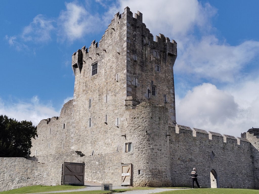
Later in the day, continue to Ross Castle on the shore of Lough Leane. The fortified tower house is closely associated with the O’Donoghue family and provides an excellent introduction to the Gaelic and early modern history of the Killarney area.
The castle exterior, lakeshore and surrounding parkland can be enjoyed without entering the building. Interior access is normally by guided tour during the visitor season, and opening arrangements should be checked before travelling.
Allow between one and two hours depending on whether you join a castle tour, walk onto Ross Island or take a boat trip on the lake. Evening light can be particularly attractive around the harbour and castle walls, although cloud and rainfall will naturally affect visibility.
Optional Lake Experience
If your arrival time and the weather allow, a boat trip from the Ross Castle area can provide an early understanding of the scale of the Lakes of Killarney. Conditions and operating schedules vary, so confirm arrangements locally rather than building your first day around a fixed departure.
Day 2: Killarney National Park, Muckross and Torc Waterfall
Your second day explores the southern section of Killarney National Park. Although many visitors attempt to combine these locations with the entire Ring of Kerry, they deserve a separate day.
Muckross House and Gardens
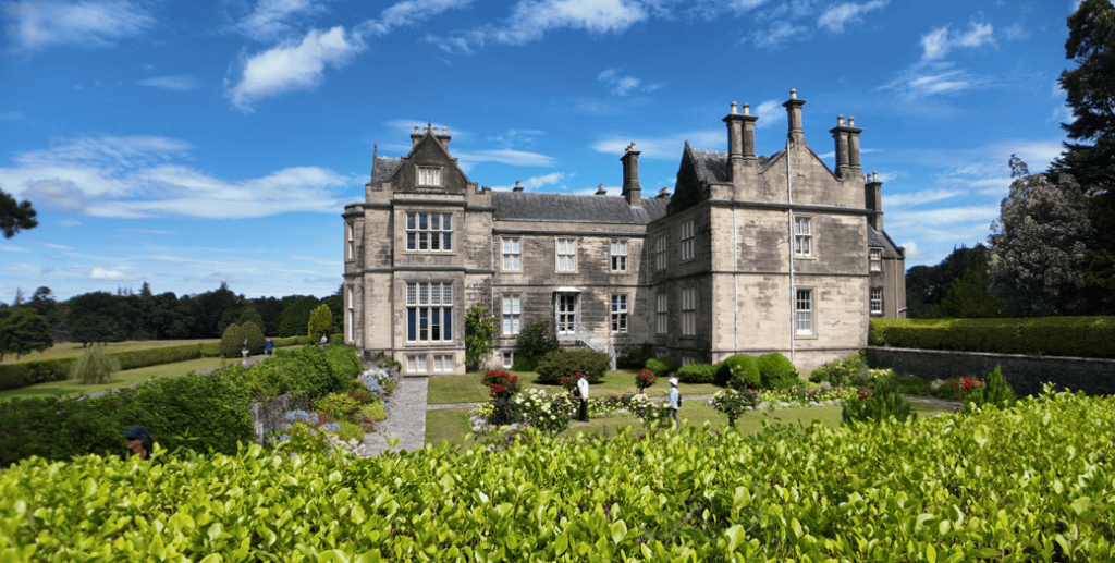
Start around Muckross House, overlooking Muckross Lake. The nineteenth-century house, landscaped gardens and surrounding estate provide a very different experience from the wilder mountain scenery nearby.
The gardens and lakeside setting are worth exploring even if you do not tour the interior. Depending on your interests, you can also include Muckross Traditional Farms, but allow sufficient time rather than treating it as a short additional stop.
Muckross Abbey
Continue to Muckross Abbey, a Franciscan friary founded in the fifteenth century. Its church, cloister and central yew tree make it one of the most atmospheric historical sites in the Killarney area.
The walk is generally straightforward, but the ground can be damp and uneven. Allow approximately 45 minutes to an hour for the abbey, more if you are approaching it as part of a longer walk through the estate.
Torc Waterfall
Torc Waterfall lies a short distance south of Muckross. The main waterfall is reached by a relatively short woodland walk, although the path rises and includes steps.
Rain often strengthens the waterfall, so this is one Kerry attraction that does not depend upon clear skies. Parking can become busy during the main visitor season. An early or later visit is usually more comfortable than arriving in the middle of the day.
Ladies View and Moll’s Gap
If visibility is good, continue along the N71 towards Ladies View and Moll’s Gap. The road climbs above the Upper Lake and reveals the relationship between Killarney’s lakes, woodland and surrounding mountains.
Take your time on this road. It is narrow in places and carries coaches, cyclists and local traffic. Use established parking areas and never stop on a bend for a photograph.
If low cloud hides the higher viewpoints, remain around Muckross and the lakes instead. You can return to Ladies View on Day 5 while travelling between Kenmare and Dingle.
Day 3: Killorglin, Glenbeigh, Cahersiveen and Valentia Island
Check out of your Killarney accommodation and begin the western side of the Ring of Kerry. This is a travelling day, but it should not feel like a transfer. The route introduces the changing landscape between Killarney, Dingle Bay and the Skellig coast.
Killorglin and the Laune Valley
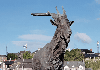
Travel west through Killorglin, where the River Laune flows from the Lakes of Killarney towards Castlemaine Harbour. The town is well known for Puck Fair, a traditional August festival with a history extending back for generations.
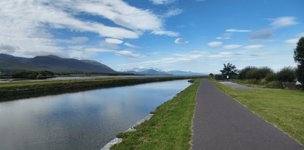
Beyond Killorglin, the road follows the southern side of Dingle Bay. The mountains across the water belong to the Dingle Peninsula, which you will explore later in the week.
Glenbeigh and Rossbeigh
Stop around Glenbeigh and consider a detour to Rossbeigh Strand. The long sandy beach extends into Dingle Bay and offers wide views of the surrounding mountains and coast.
Beach conditions vary considerably with tide and weather. Allow 30 to 60 minutes for a walk, but do not attempt to drive onto unfamiliar sections of sand. Strong winds can also make the shore feel much colder than inland areas.
Cahersiveen and the Stone Forts
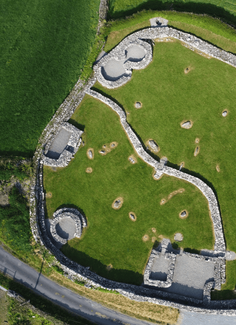
Continue to Cahersiveen, one of the principal towns on the Iveragh Peninsula. Nearby Cahergall and Leacanabuaile stone forts provide insight into settlement and defence in early medieval Ireland.
These are genuine archaeological sites rather than reconstructed visitor attractions. Wear suitable footwear, respect surrounding farmland and avoid climbing on vulnerable walls.
Visitors with a strong interest in castles, forts, monasteries and early Christian sites can plan additional stops using the Historical Sites in Kerry collection.
Valentia Island
Reach Valentia Island either by the bridge from Portmagee or, when operating, by the seasonal ferry between Renard Point and Knightstown. The bridge is the dependable year-round route; never assume the ferry will be running without checking current arrangements.
Valentia contains several worthwhile locations, including the Tetrapod Trackway, Geokaun Mountain, Valentia Slate Quarry, Knightstown and the lighthouse at Cromwell Point. Choose two or three rather than trying to rush through every attraction.
The Tetrapod Trackway preserves evidence of an early vertebrate moving across soft sediment hundreds of millions of years ago. Access involves an outdoor descent towards the shore, so conditions underfoot and Atlantic weather should be considered.
Stay overnight on Valentia Island, in Portmagee or farther south around Waterville.
Day 4: The Skellig Ring, Waterville, Derrynane and Sneem
Day four follows one of Kerry’s most varied coastal routes. The Skellig Ring runs through the western end of the Iveragh Peninsula and should be explored separately from the faster sections of the main Ring of Kerry.
Portmagee and the Skellig Coast
Begin in Portmagee, the colourful harbour village connected to Valentia Island by bridge. Boats for the Skellig Islands operate from this wider coastal area during the visitor season, but every sailing depends upon sea conditions.
A Skellig Michael landing trip is a major excursion, not a short addition to a driving day. It requires advance planning, suitable physical ability and a willingness to accept that weather may cause cancellation. If you have secured a landing trip, dedicate most of the day to it and move the remainder of this itinerary to another day.
A non-landing cruise may require less time but remains weather-dependent. The Skellig Experience near the Valentia bridge is a useful alternative when sailings do not operate or when visitors prefer to learn about the islands from land.
Kerry Cliffs and Coomanaspig Pass
Continue towards the Kerry Cliffs and the high road across Coomanaspig Pass. The landscape opens towards Puffin Island and the Skelligs when conditions are clear.
The cliff attraction involves an admission charge and an exposed walk from the parking area. Stay behind all safety barriers and expect stronger wind near the edge than at road level.
Coomanaspig is steep and confined in places. Large vehicles and nervous drivers should approach it cautiously, especially in poor visibility.
Waterville and Lough Currane
Waterville sits between Ballinskelligs Bay and Lough Currane. It is closely associated with Charlie Chaplin, who holidayed here with his family, but the village’s significance also comes from its coastal position and long connection with angling.
Stop for lunch or a walk along the seafront before continuing south. If the day is already running late, Waterville is a sensible place to finish rather than rushing the remaining coast.
Derrynane and Caherdaniel
Derrynane was the home of Daniel O’Connell, one of the most important political figures in nineteenth-century Ireland. Derrynane House, its surrounding woodland and the nearby beach deserve at least 90 minutes, and longer if you want to walk the shore.
At low tide, Abbey Island may appear accessible across the sand, but tidal conditions must be treated seriously. Do not cross unless you understand the tide and have enough time to return safely.
Sneem
Finish the day in Sneem, a village divided by the River Sneem and known for its colourful central squares. It is a comfortable place for a meal or an overnight stay before continuing towards Kenmare.
If you are staying in Kenmare, allow time for the final drive rather than leaving Sneem after dark. Kerry’s coastal roads demand more concentration at night, particularly for drivers unfamiliar with narrow bends.
Day 5: Kenmare, the Mountain Road and the Journey to Dingle
Day five connects the Iveragh and Dingle peninsulas. The direct journey is manageable, but several valuable stops make it a rewarding sightseeing day.
Morning in Kenmare
Begin with time in Kenmare, a planned heritage town at the head of Kenmare Bay. Walk through the centre, visit the stone circle and allow time for the town’s shops, cafés and craft businesses.
Kenmare works well as a quieter alternative to Killarney, but today’s route returns through the national park before turning west towards Dingle.
Moll’s Gap and Ladies View
Travel north on the N71 through Moll’s Gap. If poor visibility affected Day 2, this is your second opportunity to stop at the higher viewpoints.
The route descends through Killarney National Park towards Muckross. Drive carefully, particularly around blind corners and where larger vehicles need additional road space.
Inch Strand
From Killarney, travel through Milltown and Castlemaine towards the Dingle Peninsula. Detour to Inch Strand, a long sand spit extending into Dingle Bay.
Inch is suitable for a beach walk, photography or a longer break before continuing to Dingle. Although vehicles are often seen on part of the strand, conditions vary. Follow local signs and remain on firm, clearly used sections if driving is permitted.
Arrive in Dingle
Continue west through Annascaul and Lispole before reaching Dingle. After several days of driving, keep the evening free for the harbour, town centre and dinner.
Dingle’s streets are compact and best explored on foot. Staying within walking distance of the centre allows you to enjoy the town without needing the car again that evening.
Day 6: Slea Head Drive and the Western Dingle Peninsula
Day six is devoted to Slea Head Drive, the circular route around the western end of the Dingle Peninsula. Although the recognised circuit is relatively short, it can easily fill a day once archaeological sites, beaches and coastal viewpoints are included.
Ventry and the Southern Coast
Leave Dingle towards Ventry and continue clockwise around the peninsula. This direction generally follows the normal flow used by larger touring vehicles on the narrowest coastal section.
Ventry Harbour provides the first clear sense of the route’s geography. Beyond the village, the road begins to climb and narrow as it approaches the Atlantic coast.
Dún Beag and the Fahan Landscape
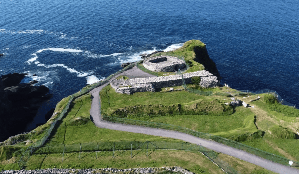
The Fahan district contains promontory forts, clocháin, inscribed stones and the remains of long-established farming settlements. Dún Beag occupies a defensive cliff-edge position, while groups of corbelled stone huts survive nearby.
Access conditions at exposed archaeological sites may change because of erosion and private management. Observe signs, pay admission where required and avoid crossing land that is not clearly open to visitors.
Slea Head and Coumeenoole
Continue around Slea Head towards Coumeenoole. The road offers views across the Blasket Sound, with the Great Blasket Island dominating the western horizon in clear weather.
Coumeenoole Beach lies beneath steep cliffs and is reached by a narrow access road. The beach is visually impressive but can be affected by strong surf and dangerous currents. Treat it as a walking and photography stop rather than assuming it is suitable for swimming.
Dunquin and the Blasket Centre
Dunquin Pier is one of the most photographed locations in Kerry, but the steep winding path is a working access route rather than an ordinary roadside viewpoint. Park only in designated areas and keep the turning space clear for local and commercial vehicles.
The nearby Blasket Centre explains the history, literature and community life of the Blasket Islands. It is one of the most useful cultural stops on the peninsula and deserves at least an hour when open.
Ballyferriter, Clogher and Gallarus
Continue through Ballyferriter, an Irish-speaking village in the West Kerry Gaeltacht. From the wider Clogher area, the Atlantic landscape changes again, with views towards the Three Sisters and Ceann Sibéal.
Finish the circuit through Gallarus and Kilmalkedar. Gallarus Oratory is among Ireland’s best-known early stone churches, while Kilmalkedar contains a Romanesque church, ogham stone and several features associated with pilgrimage.
Allow six to eight hours for a comfortable full-day circuit. A shorter version is possible, but it will require you to select fewer stops. For independent travellers, the Slea Head GPS Audio Tour provides location-based stories and guidance along the route.
Day 7: Conor Pass, North Dingle and Departure
Your final day can be adapted to your onward destination. If you are travelling towards Tralee, Limerick, Shannon or Galway, explore the northern side of the Dingle Peninsula before leaving the county. If you are returning towards Cork, you may prefer additional time around Dingle town and the southern peninsula.
Conor Pass
Conor Pass crosses the mountains between Dingle and the northern coast. The upper road is narrow, with restrictions affecting certain large vehicles, so check signs before committing to the route.
On a clear day, the viewpoint reveals a glaciated landscape of corrie lakes, steep mountain slopes and the broad coast beyond Castlegregory. In fog, heavy rain or strong wind, the experience is very different and continuing by the main road may be the more sensible choice.
Brandon Bay and Castlegregory
If conditions permit, descend towards Brandon Bay and Castlegregory. This coast is more open and less enclosed than Slea Head, with long beaches, dune systems and views towards the mountains of the Brandon range.
You can return towards Tralee through Camp, completing a natural circuit of the peninsula. Travellers heading back to Dingle should allow time for the return journey rather than underestimating the mountain and coastal roads.
Alternative Final Day in Dingle
If you prefer not to drive another complete route, use the morning for Dingle Harbour, a boat trip, shopping or a slower walk around town. This can be especially valuable after six active days.
A weather-cancelled activity from earlier in the week can also be moved here. Flexibility is one of the main advantages of spending seven days in Kerry rather than attempting to see the county over a weekend.
Driving in Kerry
Many Kerry roads are well maintained, but the most scenic sections can be narrow, twisting and shared with cyclists, walkers, coaches and farm vehicles. Journey times displayed by navigation apps do not include photography stops, traffic delays or the time required to pass safely on confined roads.
Drive on the left, use recognised parking spaces and never stop in the carriageway simply because a view appears unexpectedly. When meeting another vehicle on a narrow road, the nearest passing place may be behind you.
Fuel stations become less frequent in remote coastal districts, so avoid starting a long day with a nearly empty tank. Mobile coverage can also vary, making an offline map useful.
Weather and What to Pack
Kerry’s Atlantic weather is changeable throughout the year. A dry morning in Killarney does not guarantee clear conditions at Slea Head or on the Skellig coast.
Bring a waterproof jacket, comfortable footwear and layers that can be added or removed during the day. An umbrella is less useful on exposed headlands, where wind can make it difficult to handle.
For photography, carry a lens cloth and protect equipment from sudden showers. Do not postpone every activity because of light rain; woodland, waterfalls, historic buildings and towns can all work well when mountain visibility is poor.
Is Seven Days Enough for Kerry?
Seven days is enough for an excellent first experience of Kerry, provided you accept that you will not see every beach, island, walk and historical site. The county rewards slower travel, and trying to include everything usually reduces the quality of the visit.
This itinerary covers Kerry’s three strongest visitor regions while keeping the route geographically sensible. It also gives you options when weather or seasonal arrangements affect boats, viewpoints and outdoor attractions.
Visitors who prefer not to manage the driving can arrange a tailored itinerary through my bespoke private tours in Kerry. Individual days can be adjusted around walking ability, family interests, photography, history or accommodation plans.
Continue Exploring County Kerry
A one-week itinerary provides an introduction rather than a final answer to Kerry. Walkers may want additional time for the Kerry Way, Mount Brandon or Killarney’s mountain routes. History enthusiasts could add Ardfert Cathedral, Rattoo Round Tower, Staigue Fort and the early Christian sites of West Kerry.
Visitors interested in beaches, lakes, mountain passes and viewpoints can continue planning through Places to See in Kerry. Practical stories and seasonal travel ideas are also available on Steve’s Peninsula Blog.
If Kerry forms part of a wider Irish journey, avoid placing a long cross-country transfer immediately after your busiest sightseeing day. The private scenic transfer options can help connect Dingle and Kerry with Dublin, Shannon, Galway and other destinations while incorporating appropriate stops along the way.
Frequently Asked Questions About Spending 7 Days in Kerry
What is the best base for a week in Kerry?
There is no single ideal base for the entire county. A combination of Killarney, South Kerry and Dingle reduces repeated driving and gives better access to the principal regions.
Do I need a car to follow this Kerry itinerary?
A car provides the greatest flexibility, but it is not the only option. Trains and buses serve Killarney and Tralee, while local tours operate around the Ring of Kerry and Dingle Peninsula. Remote sites are more difficult to combine using public transport alone.
How many nights should I stay in Killarney and Dingle?
For this route, three nights in Killarney and two nights in Dingle work well. Use the remaining two nights for Portmagee, Valentia Island, Waterville, Sneem or Kenmare.
Can I visit Skellig Michael during a seven-day trip?
Yes, but landing trips are seasonal, limited and highly dependent on sea conditions. Reserve well in advance and keep another day flexible in case your sailing is cancelled.
Can the Ring of Kerry be driven in one day?
The main route can be completed in one day, but combining it with Valentia Island, the Skellig Ring and numerous historical stops creates an unnecessarily rushed experience. This itinerary divides the western and southern sections across two days.
What is the best time of year for seven days in Kerry?
Late spring through early autumn generally provides longer daylight and the widest range of visitor services. Summer is busier, while spring and autumn can be quieter but may bring shorter opening periods and more variable conditions. Kerry can be visited year-round if the itinerary remains flexible.
Should I book activities before arriving?
Book essential experiences such as Skellig Michael trips, private tours and limited-capacity attractions in advance. Keep ordinary viewpoints, beaches and short walks flexible so they can be matched to the weather.