
HISTORY COLLECTION
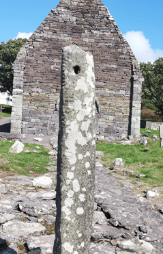
Standing within the graveyard of the Kilmalkedar ecclesiastical complex, the Kilmalkedar Ogham Stone is an early medieval inscribed pillar and one of the best-known surviving ogham monuments on the Dingle Peninsula.
Early Medieval
Kilmalkedar, Dingle Peninsula
Ogham-inscribed standing stone
Unguided public access
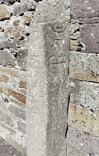
The Kilmalkedar Ogham Stone survives within a remarkable ecclesiastical landscape containing monuments from several periods. The pillar stands in the graveyard near the approach to the medieval church, alongside evidence of both ogham and Latin literacy. Its carved inscription follows the characteristic ogham practice of using the natural edge of the stone as a structural line for the letter strokes.
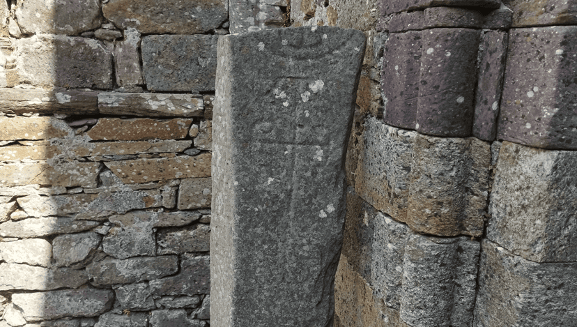
The upright pillar carries an ogham inscription conventionally dated to around AD 600.
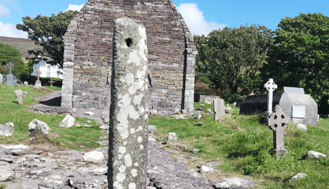
The principal inscription commemorates Máel-Inbir, son of Broccán.
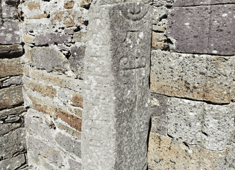
The stone forms part of a wider ecclesiastical complex containing a church, alphabet stone, sundial and cross.
Every historic site has a unique story shaped by its landscape, history and surviving remains. This section provides the key facts you need to understand the monument, including its location, historical importance and defining features, offering a solid foundation before exploring the site in greater depth.
Irish name
Og-úaim Cill Maoilchéadair
County
Kerry
Monument Type
Ogham-inscribed standing stone
National Monument Number
NA
Historical Period
Early Medieval
Ownership
State-owned National Monument
Date
6th–early 7th century AD
Condition
Survives upright
Townland
Kilmalkedar
Archaeological Investigation
3D recording undertaken in 2013
Civil Parish
Kilmalkedar
Public Access
Public access
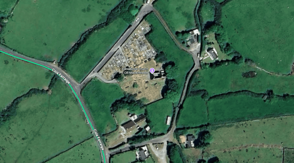
Latitude
52.184927
Longitude
-10.335644
Address
Kilmalkedar, Dingle, Co. Kerry
Nearest Town
Ballyferriter
Road access
R559
Monumental ogham emerged in Ireland during the fourth or fifth century AD and continued to be used on standing stones into the seventh century. The script recorded an early form of Irish and was commonly carved along the natural edges of upright stones. The Dingle Peninsula is particularly important to this tradition, containing the highest concentration of ogham stones known in Ireland.
Kilmalkedar Ogham Stone Church View
The Kilmalkedar stone belongs to the later phase of this monumental tradition. Its exact date cannot be established directly, but linguistic and epigraphic evidence supports a date in the sixth or early seventh century, while the Office of Public Works conventionally dates it to around AD 600.
Its principal inscription reads ANM M(AI)LE INBIR MACI BROCANN, interpreted as commemorating Máel-Inbir, son of Broccán. The formula records identity through descent, providing evidence for the importance of personal names, genealogy and social memory in early medieval Ireland. The inscription does not identify Máel-Inbir’s occupation, social rank or place of residence.
The stone’s precise original purpose remains uncertain. Its inscription strongly supports a commemorative function, while interpretations involving territorial or legal significance are possible but unproven. Although it now stands within a graveyard, there is no excavated evidence demonstrating that it originally marked a particular burial.
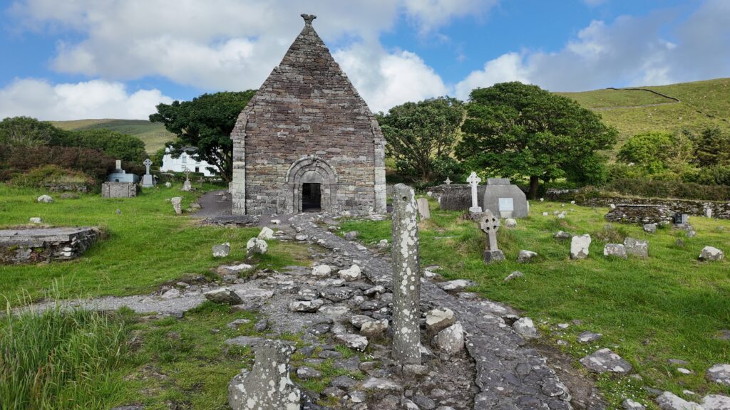
Over subsequent centuries, Kilmalkedar developed into an important ecclesiastical and burial complex. An alphabet stone, sundial, cross and other features accumulated within the site, while the surviving Romanesque church was constructed after 1134. The continued presence of the ogham pillar within this later Christian landscape illustrates the long history of commemoration and literacy at Kilmalkedar without proving that every surviving monument belonged to the same period.
The inscription preserves the name of Máel-Inbir and his father Broccán, but neither individual has been securely identified in surviving annals or genealogies. The stone records their names, not their biographies.
Unlike the later church at Kilmalkedar, the ogham pillar is not architecture in the conventional sense. Its construction instead involved selecting, preparing and erecting a substantial stone capable of carrying an inscription while remaining stable as a freestanding monument.
The pillar stands approximately 1.8 metres above the present ground level. Its natural edge, or arris, provided the structural line around which the ogham characters were arranged. This was characteristic of monumental ogham: strokes and notches were cut in relation to the edge rather than across a prepared flat writing surface.
Creating the inscription required careful planning. The carver needed to understand the ogham alphabet, maintain the correct number and arrangement of strokes and accommodate the available space along the stone. The cuts were probably produced using a hard metal tool through repeated incision or pecking. The precise quarry source and geological composition of the Kilmalkedar pillar have not been established.
Erecting a stone of this size would have required support below ground, probably involving a prepared socket with packing stones or compacted soil. However, the buried portion has not been archaeologically documented, so its original depth, packing arrangement and even whether the present socket represents its first position remain unknown.
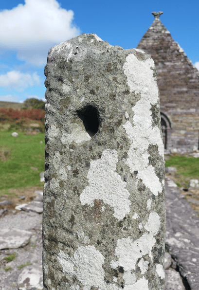
The pillar also contains a conspicuous perforation. Although this feature has attracted interpretations, the available evidence does not establish when the hole was made or what purpose it served. It should therefore not be presented as a confirmed element of the monument’s original design.
The Edge Was Part of the Writing System
Ogham inscriptions commonly used the natural edge of a standing stone as a stemline. At Kilmalkedar, the physical form of the pillar was therefore integral to the arrangement and reading of its inscription.
Kilmalkedar Ogham Stone Carvings
The Kilmalkedar Ogham Stone has not been securely dated through excavation or scientific dating. Stone itself cannot be radiocarbon dated, and no radiocarbon determination records the act of carving. Instead, archaeologists and epigraphers — specialists who study inscriptions — rely principally on the language, letter forms and comparison with other ogham monuments. This evidence places CIIC 187 broadly in the sixth or early seventh century, with the Office of Public Works giving a conventional date of around AD 600.
Kilmalkedar Ogham Stone Pierced Top
The principal inscription is normally transcribed as ANM M(AI)LE INBIR MACI BROCANN. A practical translation is “The name of Máel-Inbir, son of Broccán.” Some damaged or ambiguous letters require scholarly restoration, but the broad commemorative formula is considered secure.
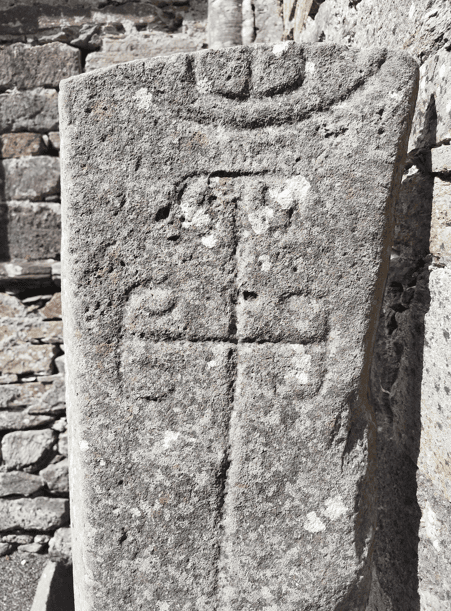
A second, much shorter inscription also survives on the pillar. It has been reported as ANM or M(A)Q(I), but its preservation is too poor to support a confident reading. It could indicate reuse, recutting or a separate commemorative episode, although none of these possibilities has been demonstrated archaeologically.
The stone’s archaeological context also requires caution. Its long-standing presence within an early ecclesiastical and burial site makes an original or near-original position plausible, but the present socket has not been demonstrated through modern excavation to be its first setting. Similarly, its commemorative inscription and graveyard location make a connection with burial possible, but there is no excavated burial association proving that the pillar functioned as a grave marker.
Modern technology has provided an important new archaeological record. In 2013, the School of Celtic Studies at the Dublin Institute for Advanced Studies, working with the Discovery Programme, recorded the monument in three dimensions through the Ogham in 3D project. This preserves detailed information about the stone’s geometry, inscription and surface for future study and comparison.
How Do We Date an Ogham Stone?
The date of around AD 600 is not written on the monument. It is a scholarly approximation based principally on linguistic development, epigraphic comparison and archaeological context rather than direct scientific dating.
The Kilmalkedar Ogham Stone provides only a narrow window into everyday life. It does not describe homes, occupations, food or ordinary activities. What it does preserve is direct evidence of how identity and family relationships could be expressed publicly in early medieval Ireland.
The principal inscription names Máel-Inbir and identifies him through his father, Broccán. The use of the kinship formula MACI, meaning “son of”, reflects a society in which descent was an important element of identity. Inscribed monuments could preserve personal memory and communicate relationships between individuals and their kin.
Producing such an inscription also required specialised knowledge. Ogham was an alphabetic writing system in which combinations of strokes and notches represented sounds. A carver needed to understand these values, the direction in which the inscription was read and the formulaic language used to record names and relationships.
The wider Kilmalkedar complex preserves evidence of another writing tradition through its alphabet stone, conventionally dated to around AD 550–600. The presence of ogham and Latin literacy within the same archaeological landscape makes Kilmalkedar particularly significant for understanding different forms of written communication in early medieval Ireland.
It is possible that monuments such as this also communicated status, territorial claims or legal relationships. These interpretations are supported by wider studies of ogham stones, but they cannot be demonstrated specifically for Máel-Inbir or the Kilmalkedar pillar. The inscription itself gives him no title and does not establish whether he was a cleric, ruler or member of a particular dynasty.
Identity Through Family
The inscription identifies Máel-Inbir through his father, Broccán. This patronymic formula provides direct evidence that descent and family relationships formed part of the way individual identity could be recorded publicly in early medieval Ireland.
Kilmalkedar Ogham Stone Cross Carving
Kilmalkedar lies on the northern side of the Dingle Peninsula within the historic cultural region of Corca Dhuibhne, overlooking Smerwick Harbour. The ecclesiastical complex extends across more than ten acres and contains monuments accumulated over centuries of burial, commemoration, worship and pilgrimage.
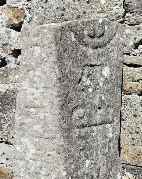
Kilmalkedar Ogham Stone Carved Face
The ogham stone forms part of a wider archaeological landscape of inscribed stones, ecclesiastical centres, ringforts, routeways and coastal settlement. The Dingle Peninsula is particularly significant for ogham, with approximately sixty stones originating in the region, while County Kerry contains roughly one third of the known national corpus.
This concentration suggests that inscribed stones were an important means of expressing personal identity and kin memory in early medieval west Kerry. Wider archaeological studies also allow the possibility that some ogham stones were connected with territorial boundaries or claims to land, although such a function has not been demonstrated for the Kilmalkedar stone itself.
Kilmalkedar also belongs to a landscape associated with pilgrimage traditions connected with Mount Brandon. Within the immediate site, the ogham pillar stands among the later church, alphabet stone, sundial, stone cross and graveyard. Together, these monuments demonstrate the long-term importance of this location, although they were created at different periods and should not be interpreted as a single contemporary group.
The site’s exposed Atlantic environment has also influenced the monument’s survival. High rainfall, wind-driven moisture and salt-bearing air contribute to the conditions affecting exposed carved stone, while continued burial, paths, vegetation management and visitor activity have altered the surrounding graveyard over time.
A Regional Centre for Ogham
The Dingle Peninsula contains the highest concentration of ogham stones known from Ireland, with approximately sixty originating in the region. Kilmalkedar’s pillar therefore survives within one of Ireland’s most important landscapes for the study of early Irish writing.
Follow the story of the Kilmalkedar Ogham Stone from the early centuries of Ireland’s ogham tradition through its later place within the ecclesiastical landscape at Kilmalkedar. The timeline traces the principal periods and evidence that help place this inscribed pillar within the wider history of early Irish writing on the Dingle Peninsula.
Ogham was used on standing stones in Ireland during this period, recording the earliest surviving written form of Irish.
The most defensible date range for CIIC 187. The OPW conventionally dates the monument to around AD 600.
The nearby alphabet stone provides evidence for Latin literacy within the developing ecclesiastical landscape.
The OPW gives AD 636 as the traditional death date of St Maolcethair, with whom the ecclesiastical complex is associated.
The surviving Romanesque church was built centuries after the ogham inscription, reflecting the site’s continuing ecclesiastical importance.
DIAS and the Discovery Programme recorded the ogham stone in three dimensions, creating a detailed digital record of the monument.
The stone survives as part of the state-owned Kilmalkedar National Monument in OPW care, with unguided public access.
The Kilmalkedar Ogham Stone stands within the historic ecclesiastical complex at Kilmalkedar on the Dingle Peninsula. Before visiting, it is useful to understand the site’s access, limited parking and its setting within an active graveyard, where visitors should explore carefully and respectfully.
Kilmalkedar ecclesiastical complex, Dingle Peninsula, County Kerry
Free parking is available beside the Office of Public Works right of way (limited spaces).
Unguided public access within an active graveyard; uneven ground and weather-dependent outdoor conditions
Admission is free.
Daylight hours in good weather
Riasc, Gallarus Oratory, Gallarus Castle, Ballintaggart ogham group and other monuments within the Kilmalkedar complex
Explore more historic places, monuments and archaeological sites across County Kerry.
You can experience the Kilmalkedar Ogham Stone with Steve as part of a private tour of the Dingle Peninsula. Visiting the stone in its historic setting provides an opportunity to examine one of Ireland’s distinctive early inscribed monuments while exploring the wider ecclesiastical landscape at Kilmalkedar.
If you would rather leave the driving behind, I offer private tours across the Dingle Peninsula and County Kerry. Each experience is designed for small private groups, with a relaxed pace, local knowledge and the flexibility to spend more time at the places that interest you most.
A relaxed three-hour private tour around Slea Head and the spectacular western coastline of the Dingle Peninsula.
Explore Slea Head, ancient heritage sites, coastal viewpoints and the landscapes of West Kerry on a private half-day experience.
Discover more of the Dingle Peninsula with a full day to explore its scenery, history, villages and lesser-known places.
Journey around the Iveragh Peninsula, combining the Ring of Kerry with the dramatic landscapes and Atlantic coastline of the Skellig Ring.
Explore Killarney National Park, its lakes, mountain viewpoints, waterfalls and some of the most beautiful landscapes in County Kerry.
Travel north from Kerry for a private day tour through the Burren to the spectacular Cliffs of Moher on Ireland’s Atlantic coast.
Create a private Kerry itinerary around the places, landscapes and experiences that matter most to you.
The Kilmalkedar Ogham Stone has been documented through epigraphic study, archaeological records, three-dimensional recording and specialist scholarship on early Irish writing. The principal sources below provide evidence for its inscription, chronology, archaeological context and place within the wider ogham tradition.
Office of Public Works / Heritage Ireland
Kilmalkedar Church — official National Monument record and visitor information. Principal source for the monument’s dimensions, conventional date, inscriptions, site context, legal status and access.
Dublin Institute for Advanced Studies & The Discovery Programme
Ogham in 3D: CIIC 187, Kilmalkedar (Cill Maoilchéadair), Co. Kerry — specialist digital monument and inscription record, including the 3D recording undertaken in 2013.
The Heritage Council
Fionnbarr Moore, Nora White and associated contributors, Our Ancient Landscapes: Ogham Stones in Ireland (2021) — specialist synthesis covering ogham chronology, distribution, archaeological context, interpretation and conservation.
National Monuments Service
National Monuments in State Care: Ownership and Guardianship – County Kerry — official source for the monument’s legal and management context.
R. A. S. Macalister
Corpus Inscriptionum Insularum Celticarum, Vol. I (1945) — foundational scholarly corpus providing the CIIC classification and historical epigraphic framework for the monument.
Specialist Ogham Scholarship
Damian McManus, A Guide to Ogam (1991); Sabine Ziegler, Die Sprache der altirischen Ogam-Inschriften (1994); Catherine Swift, Ogam Stones and the Earliest Irish Christians (1997) — Specialist studies of ogham language, chronology, inscriptions and their early Irish historical context.
Loading availability…