Staigue Fort is one of the most impressive stone forts on the Iveragh Peninsula and one of the historical places I think deserves more than a quick photograph while travelling around the Ring of Kerry. Hidden inland from the Atlantic coast, the fort sits within a broad mountain landscape that helps explain why this particular site is so memorable.
The Story of One of Kerry’s Great Stone Forts
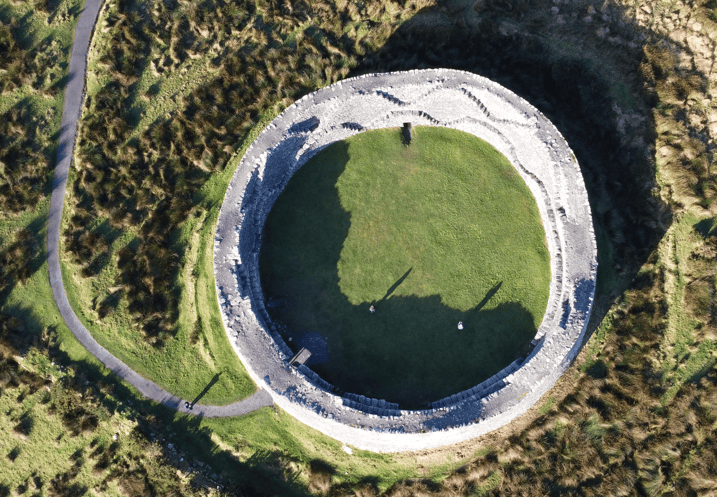
Known in Irish as Cathair na Stéige, Staigue Fort is a large circular stone enclosure built without mortar. The monument stands in the townland of Staigue on the southern side of the Iveragh Peninsula, inland from the Ring of Kerry road between the Sneem and Caherdaniel areas.
The surviving structure is remarkable for the scale of its walls, carefully controlled entrance and the quality of its dry-stone construction. Standing inside the fort, the surrounding mountains rise beyond the stone walls and make it much easier to understand that this was once part of a much larger lived landscape rather than an isolated archaeological monument.
Its exact date remains uncertain. Staigue has been assigned widely differing dates over the years, and it is better to acknowledge that uncertainty than present one speculative construction date as established fact. What is clear is that it belongs to Ireland’s tradition of substantial defended stone enclosures and represents an extraordinary level of stone-building skill.
Where Is Staigue Fort?
Staigue lies on the southern Iveragh Peninsula in County Kerry, inland from the coastal road followed by the Ring of Kerry.
The fort is reached by leaving the main touring route and travelling inland through a quieter rural landscape. That short diversion is an important part of the experience because the surrounding mountains gradually close around the road before the fort appears within the valley.
Visitors often concentrate so heavily on Kerry’s Atlantic coastline that they forget how important its inland valleys and mountain landscapes are. Staigue provides an excellent example. You are not standing above a dramatic sea cliff or beside a famous beach; you are surrounded by land that feels naturally enclosed by the mountains.
The official Irish placename is Cathair na Stéige, while Staigue is the English form generally used by visitors. The monument lies in the civil parish of Kilcrohane within the historic barony of Dunkerron South.
What Type of Monument Is Staigue Fort?
Staigue is generally described as a stone fort or cashel. These substantial circular enclosures belong to the wider family of Irish ringforts, although stone rather than earth forms the principal surviving defensive boundary.
Ringforts are among the most characteristic archaeological monuments in the Irish countryside. Many consist of an earthen bank and ditch surrounding a farmstead or residence. In areas where suitable stone was readily available, substantial stone-built enclosures could instead be created.
Staigue is exceptional because of its scale and preservation. The walls are more than four metres thick in places, creating an imposing structure even without knowing its precise date or original occupants.
It is worth remembering that a fort like Staigue should not automatically be imagined as a military fortress in the modern sense. Large ringforts and cashels could represent defended residences, farmsteads and centres of local status as well as providing protection.
The Dry-Stone Walls
The first thing most visitors notice is the thickness of the walls.
Staigue was constructed using dry-stone masonry, meaning the stones were carefully selected and fitted without mortar binding them together. This type of building requires considerable skill. Stability depends upon the placement, weight and interaction of the stones rather than a cementing material holding everything in position.
The walls create a substantial circular enclosure. Their thickness allowed internal features to be incorporated into the structure, including passages and stairways that provided access to higher levels.
When I visit sites like Staigue, I always encourage people to look beyond the overall shape and examine the individual stones. The craftsmanship becomes more impressive once you begin thinking about how much material had to be collected, selected and positioned to create a wall of this scale.
The Entrance Passage
The fort is entered through a narrow passage on the southern side.
This entrance is one of the most interesting architectural features because the walls become particularly substantial around it. The passage emphasises the difference between the open countryside outside and the enclosed interior of the fort.
Heritage Ireland records the entrance passage as approximately two metres high and notes that it passes through a wall over four metres thick.
The controlled nature of the entrance also reminds us that access mattered. Visitors today can walk casually through the opening, but historically this would have been the principal controlled point through a considerable defensive boundary.
Inside Staigue Fort
Once through the entrance, the scale of the interior becomes much clearer.
The enclosure is almost circular, with high stone walls surrounding a relatively open internal area. Features within the thickness of the walls include internal passages and stairways.
Some visitors expect the interior to contain obvious surviving houses. The main visual impact today comes instead from the massive enclosure itself.
That is another reason context matters. Archaeological monuments rarely survive exactly as they functioned when occupied. Roofed structures, timber features and everyday objects may disappear while stone walls remain.
The fort we experience today is therefore only part of the original lived site.
Who Built Staigue Fort?
We do not know the identity of the people who originally constructed Staigue with enough certainty to attach a particular named family or ruler to the surviving monument.
Its scale suggests considerable organisation and access to labour. Building walls of this thickness required much more than the efforts of one household working casually over a few days.
Large stone forts are often interpreted as places connected with relatively prosperous or high-status communities. The monument may have served a local elite residence, protected farmstead or regional centre within the surrounding territory.
Without secure dating and documentary evidence, however, it is important not to turn those reasonable archaeological interpretations into a fictional biography of the fort’s builders.
How Old Is Staigue Fort?
The dating of Staigue has been debated for generations.
You may encounter surprisingly precise dates attached to the fort in visitor literature. Some descriptions place it in the Iron Age, while other archaeological interpretations favour later dates within the early medieval period.
The difficulty is that the surviving structure does not provide a straightforward construction date by itself. Monument types can also remain in use or develop over long periods.
For that reason, I think the most useful approach for a visitor is to appreciate Staigue as an ancient Irish stone fort whose exact chronology remains debated rather than allowing an uncertain date to dominate the experience.
Why the Location Matters
Staigue’s setting is one of the strongest reasons to visit.
The fort stands around 150 metres above sea level within a mountain amphitheatre. Once you are there, the choice of location begins to make much more sense.
The surrounding landscape would have provided agricultural resources, grazing land and natural visibility across the wider area. At the same time, the mountains give the fort a sense of enclosure that is very different from exposed coastal monuments elsewhere in Kerry.
This is why archaeological sites should be experienced in their landscapes whenever possible. A floor plan can explain the dimensions of Staigue, but it cannot show you how the monument sits within the Iveragh Peninsula.
Staigue Fort and the Ring of Kerry
Most modern visitors encounter Staigue while travelling around the Ring of Kerry.
The Ring of Kerry and Skellig Ring connect some of County Kerry’s most varied landscapes, from Killarney’s lakes and mountains to Atlantic villages, headlands and historic sites around the Iveragh Peninsula.
Staigue adds something particularly valuable to that journey. Much of the Ring of Kerry experience is understandably centred on scenery. The fort reminds you that people have occupied and shaped the Iveragh landscape for centuries.
If you are comparing Kerry’s two best-known touring regions, my guide to the Ring of Kerry versus the Dingle Peninsula explains how the two landscapes differ in scale, archaeology, driving and visitor experience.
Sneem and the Eastern Approach
Travelling from Killarney or Kenmare around the southern Ring of Kerry, Sneem is one of the principal villages encountered before reaching the Staigue area.
The colourful village sits beside the River Sneem and makes a natural coffee or lunch stop during a longer touring day.
From Sneem, the Ring of Kerry continues west through increasingly open countryside. The route gradually moves away from the sheltered Kenmare Bay landscape and towards the more Atlantic-facing western Iveragh Peninsula.
Staigue works particularly well in this part of the journey because it breaks the day into something more than a sequence of roadside viewpoints.
Derrynane and Caherdaniel
Continue west from Staigue and the landscape opens towards Caherdaniel and Derrynane.
Derrynane is closely associated with Daniel O’Connell, one of the most important political figures in nineteenth-century Ireland. His ancestral home at Derrynane forms part of a wider historic landscape of woodland, coastline and estate grounds.
The contrast with Staigue is striking. In a relatively short journey you can move from an ancient stone enclosure to a landscape associated with nineteenth-century Irish political history.
That is one of the strengths of touring the Iveragh Peninsula: historical periods are layered surprisingly close together.
Waterville and Ballinskelligs Bay
Further west, Waterville sits overlooking Ballinskelligs Bay.
The town provides another natural stopping point during a Ring of Kerry journey and marks the transition towards the western side of the peninsula and the Skellig Ring.
Waterville’s broad Atlantic setting could hardly be more different from Staigue’s enclosed mountain valley, yet the two places are relatively close within a full-day itinerary.
This constant change in landscape is why I would never advise trying to experience the Ring of Kerry as a high-speed loop. The value comes from stopping long enough to understand how each part of the peninsula differs.
Portmagee and the Skellig Coast
A complete Iveragh journey can continue towards Portmagee, one of the principal villages on the Skellig Coast.
The village sits opposite Valentia Island and has long been associated with fishing and maritime life. Today it is also one of the mainland departure points for licensed seasonal boat services towards Sceilg Mhichíl.
Portmagee provides another useful contrast with Staigue. One site takes us into the land-based settlement history of the Iveragh Peninsula; the other opens the story towards the Atlantic and islands offshore.
Staigue Fort and Other Kerry Ringforts
Staigue is not the only substantial stone fort on the Iveragh Peninsula.
Cahergall and Leacanabuaile near Cahersiveen are other important examples of stone ringfort architecture, while Loher Ringfort lies further west near Ballinskelligs Bay.
Seeing more than one fort is useful because it prevents the monuments from blending into a single category of ‘ancient ruins’. Their size, layout, surrounding landscape and surviving internal structures differ.
Visitors particularly interested in Kerry archaeology can explore the wider Historical Sites in Kerry collection to understand how the county’s forts, churches, castles and early Christian monuments connect.
What Staigue Tells Us About Ancient Ireland
One of the problems with describing archaeological monuments is that impressive stonework can make us concentrate entirely on warfare and defence.
Staigue was also a place connected with everyday human life.
People needed food, livestock, water, shelter and routes through the surrounding countryside. Communities had social hierarchies, neighbours, trading relationships and family connections.
The enormous stone wall tells us something about protection and status, but the surrounding landscape reminds us that this was ultimately part of a working society.
That is the perspective I find most useful: not imagining Staigue simply as an empty fortress, but as the surviving stone framework of a much richer human environment.
Visiting Staigue Fort Today
Staigue Fort is a state-owned National Monument in the care of the Office of Public Works.
Heritage Ireland currently identifies the site as an unguided monument with access during daylight hours. A visitor parking area is provided and access to the fort itself is by a walking path.
The site has uneven surfaces and uneven walking conditions, something worth considering for visitors with reduced mobility.
Facilities are limited. Heritage Ireland notes that a public toilet may be available but may also be closed, so I would not plan a visit assuming full visitor-centre facilities will be operating.
For the practical details of the monument itself, use my dedicated Staigue Fort visitor page before travelling.
The Road to Staigue Fort
The journey from the main Ring of Kerry route to Staigue is along smaller rural roads.
This is not unusual in Kerry, but visitors unfamiliar with Irish countryside driving should allow more time than the distance on a map might suggest.
Roads can be narrow and local traffic, farm vehicles and other visitors need to be accommodated. Drive slowly, use appropriate passing places and never assume that a road is empty simply because it appears quiet.
The benefit is that leaving the main touring route changes the atmosphere immediately. Traffic falls away and the mountains become increasingly dominant as you approach the fort.
How Much Walking Is Required?
Staigue does not require a major hike.
There is a walk from the parking area to the monument, and once at the fort visitors naturally move around the interior and exterior to appreciate the stonework.
The ground can be uneven, particularly after wet weather, so comfortable footwear is sensible.
I would also allow time simply to walk away from the entrance and look back at the complete structure within its landscape. Some of the best views of archaeological monuments are not necessarily found standing directly beside the wall.
How Long Should You Spend at Staigue Fort?
For most visitors, around 30 to 45 minutes is a sensible allowance once you reach the parking area.
That gives you enough time to walk to the monument, explore the interior, examine the entrance and wall passages and appreciate the surrounding landscape.
History enthusiasts and photographers may naturally want longer.
The biggest timing mistake is not usually spending too long at Staigue. It is forgetting to allow for the slower rural road between the main Ring of Kerry route and the site.
Staigue Fort in Kerry Weather
The fort is exposed enough that Kerry weather should be taken seriously.
Rain can make the stonework darker and emphasise the texture of the walls, while broken cloud across the surrounding mountains can create particularly atmospheric conditions.
Wet weather can also make paths and uneven ground more slippery.
I would bring a waterproof layer and wear comfortable footwear even if conditions appear settled when you leave Killarney or Kenmare. Weather can be surprisingly localised around the Iveragh Peninsula.
Photography at Staigue Fort
Staigue is particularly good for photography because the monument can be approached in several different ways.
The entrance passage provides strong architectural detail, while the interior reveals the thickness and height of the walls.
From further away, the complete fort can be photographed against the surrounding mountain landscape. That wider view is important because it shows the geographical context that close-up photographs cannot.
An aerial perspective, where legally and safely obtained under current drone regulations and land-access rules, reveals the near-circular form particularly clearly.
For ordinary photography, however, there is no need for specialist equipment. Simply moving around the monument and looking at how the light falls across the stone can produce very different images.
Is Staigue Fort Worth the Detour?
For anyone interested in Irish history, archaeology or traditional stone construction, I think it is.
The detour from the main Ring of Kerry road requires additional time, which means some visitors skip it in favour of staying directly on the touring circuit.
That is precisely why Staigue can be so rewarding.
You leave the busier road, travel inland and arrive somewhere that feels very different from the coastal viewpoints encountered elsewhere during the day.
If your only objective is to complete the Ring of Kerry as quickly as possible, Staigue will feel inconvenient. If your aim is to understand the Iveragh Peninsula, it adds considerable value.
Staigue Fort on a Private Ring of Kerry Tour
Staigue fits naturally into a full-day journey around the Iveragh Peninsula because it provides historical depth between the villages and coastal landscapes.
On my private Ring of Kerry and Skellig Ring experience, the route is shaped around conditions, available time and the interests of the people travelling with me.
For guests particularly interested in archaeology, a site such as Staigue can deserve more time than another roadside viewpoint. For photographers, weather and light may influence where we stop longest.
That flexibility is important on a route as large as the Ring of Kerry. Trying to visit every possible attraction in one day is rarely the best experience.
Continue Exploring the Iveragh Peninsula
Staigue Fort belongs within a much wider journey through southern and western Kerry.
To the east, Sneem provides a colourful village stop before the route continues towards Kenmare and Killarney. To the west, Waterville and the Skellig Coast lead towards Portmagee, Valentia Island and some of the most dramatic Atlantic landscapes on the Iveragh Peninsula.
The wider Explore Kerry collection is useful if you are planning several days in the county, while Places to See in Kerry connects the historical landscape with beaches, mountain passes, lakes and scenic viewpoints.
Staigue is ultimately memorable because of the combination of monument and place. The walls are extraordinary, but the mountains surrounding them complete the experience. Stand inside the fort, look beyond the entrance towards the landscape and it becomes much easier to imagine why communities chose to live and build here centuries ago.
Frequently Asked Questions About Staigue Fort
What is Staigue Fort?
Staigue Fort is a large circular dry-stone fort or cashel on the southern Iveragh Peninsula in County Kerry. Its massive walls, narrow entrance and internal passages make it one of Ireland’s most impressive surviving stone forts.
How old is Staigue Fort?
The precise construction date remains uncertain. Different dates have been proposed, ranging from the Iron Age into the early medieval period, so it is better to describe Staigue as an ancient stone fort without presenting an uncertain date as established fact.
Where is Staigue Fort?
Staigue Fort lies inland from the southern Ring of Kerry route, in Staigue townland on the Iveragh Peninsula. It is reached by leaving the main coastal road and following smaller rural roads into the surrounding mountain landscape.
Is Staigue Fort on the Ring of Kerry?
Staigue is commonly visited as part of the Ring of Kerry, although the fort itself requires a detour inland from the main touring road.
Do you have to pay to visit Staigue Fort?
Staigue is a state-owned National Monument and is currently listed by Heritage Ireland as an unguided site with daylight access. As visitor arrangements can change, check current official information before travelling.
Is there parking at Staigue Fort?
Yes. Heritage Ireland currently lists a car park for visitors, with a walking path continuing towards the monument.
How long should I spend at Staigue Fort?
Allow roughly 30 to 45 minutes for most visits once you arrive, with longer worthwhile if you are particularly interested in archaeology or photography.
Is Staigue Fort suitable for visitors with limited mobility?
The official visitor information notes uneven surfaces and uneven walking conditions. Visitors with specific mobility requirements should check current access information before travelling rather than assuming the site is fully accessible.
What towns are near Staigue Fort?
Staigue lies on the southern Iveragh Peninsula between the broader Sneem and Caherdaniel areas. It fits naturally into a Ring of Kerry journey continuing towards Waterville and the Skellig Coast.
Is Staigue Fort worth visiting?
Yes, particularly if you enjoy archaeology, Irish history or stone architecture. The quality of the surviving fort is impressive, but its greatest strength is the way the monument sits within the surrounding Iveragh mountain landscape.