
HISTORY COLLECTION
Riasc, also known as Reask, is an early medieval ecclesiastical settlement on the western Dingle Peninsula. Within its substantial stone enclosure, archaeological excavation revealed a small oratory, clocháns, burial areas and evidence of craft and food-processing activity.
Early Medieval
An Riasc, County Kerry
Ecclesiastical Settlement
Unguided Public Access
The surviving remains reveal the organisation of a small early medieval ecclesiastical community. Excavation identified areas associated with worship and burial alongside domestic buildings, food processing and craft production, all contained within a substantial irregular oval enclosure. The structures visible today were excavated and conserved during the 1970s, allowing much of the settlement’s internal plan to be understood.
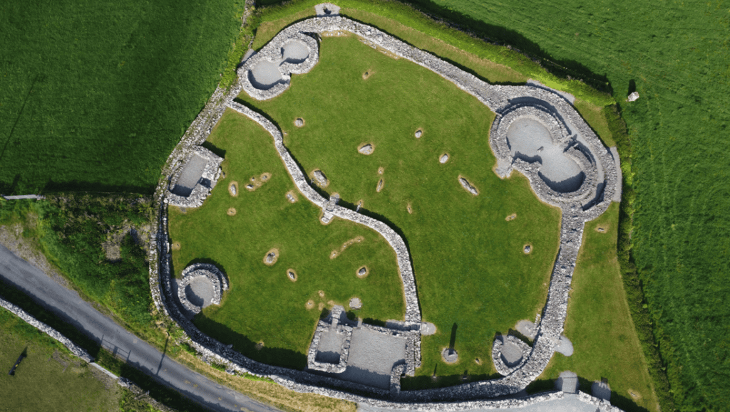
A small dry-stone oratory was constructed after some of the settlement’s earlier burials.
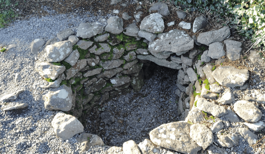
The remains of a corn-drying kiln at Riasc, used to dry cereal crops as part of food preparation and storage.
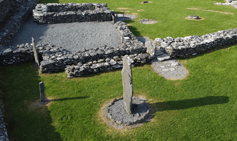
Cross-inscribed stones provide important evidence of the settlement’s early Christian identity.
Every historic site has a unique story shaped by its landscape, history and surviving remains. This section provides the key facts you need to understand the monument, including its location, historical importance and defining features, offering a solid foundation before exploring the site in greater depth.
Irish name
An Riasc
County
Kerry
Monument Type
Early Medieval Ecclesiastical Settlement
National Monument Number
519
Historical Period
Early Medieval
Ownership
State-owned; OPW care
Date
Probably 5th–7th centuries
Condition
Excavated and conserved remains
Townland
An Riasc / Reask
Archaeological Investigation
Excavated 1972–1975
Civil Parish
Márthain / Marhin
Public Access
Unguided public access
Latitude
52.167696
Longitude
-10.385868
Address
Reask, Co. Kerry
Nearest Town
Ballyferriter
Road access
R559
Riasc developed as a small early medieval ecclesiastical settlement rather than the large monastic centre that the word “monastery” can sometimes suggest. No surviving medieval document securely identifies its founder, patron saint or precise foundation date, so its history is reconstructed primarily through archaeology.
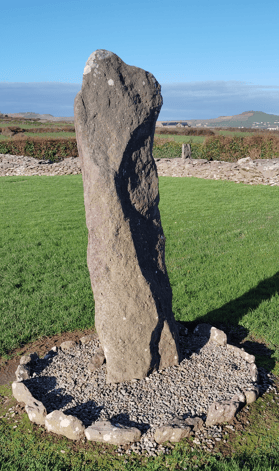
Riasc Cross Inscribed Pillar Stone
The earliest recognised phase appears to have combined religious, domestic and productive activity within an enclosed settlement. Clocháns provided living or working spaces, while evidence for cereal processing, metalworking and other crafts demonstrates that the community was not concerned solely with worship. Imported pottery and glass also show that Riasc participated in wider networks of exchange extending beyond the Dingle Peninsula.
Burial became an important part of the site. Nearly forty long lintel graves were arranged around a possible early sacred focus. Significantly, some of these burials existed before the small stone oratory was constructed. This shows that the religious centre of Riasc changed over time rather than being created as one planned development.
Following the abandonment of the oratory, smaller stone-set graves were inserted into the site. In later centuries Riasc was remembered and used locally as a ceallúnach, a burial ground associated with people buried outside ordinary consecrated graveyards. Archaeological evidence confirms this later reuse, but poor skeletal preservation means the identities of individual people buried here cannot be established.
Today, Riasc is understood as a working ecclesiastical community in which worship, burial, domestic life and productive activity existed alongside one another. Its surviving remains represent several phases of occupation and reuse, providing an unusually detailed picture of a small early medieval settlement in Corca Dhuibhne.
The cemetery was already in use before the surviving stone oratory was constructed. This archaeological sequence demonstrates that Riasc’s sacred centre developed and changed during the life of the settlement rather than belonging to a single phase of construction.
Riasc was constructed predominantly using local stone laid without mortar. Its substantial enclosure formed an irregular oval approximately 45 metres by 40 metres, with walls generally more than two metres wide. Large upright slabs, known as orthostats, were incorporated at intervals, while variations in the wall’s alignment and construction indicate that parts were rebuilt or substantially altered over time.
Within the enclosure were several clocháns — stone-built structures traditionally associated with early medieval settlement in western Ireland. Two pairs were constructed as adjoining buildings, with one northern pair connected internally. Large stone slabs were also used to pave entrances.
Stone rings around some of the clocháns may have helped retain turf packed against their walls. Archaeologically, this has been interpreted as a possible method of insulation or weatherproofing, although the turf itself does not survive.
The small rectangular oratory measured approximately 3.5 metres by 2.7 metres internally. Only parts of its walls, doorway and threshold survived excavation. Its rounded eastern corners led archaeologist Thomas Fanning to suggest that it may originally have had a corbelled dry-stone roof, formed by progressively overlapping courses of stone. This roof does not survive, so the reconstruction remains an architectural interpretation rather than an established feature.
Together, the enclosure, interconnected clocháns, paved entrances and carefully constructed stone buildings demonstrate specialised knowledge of dry-stone construction and deliberate organisation of space within the settlement.
Some clocháns were constructed as connected pairs rather than isolated buildings. Their shared walls, paved entrances and internal communication indicate deliberate planning in the organisation of Riasc’s domestic spaces.
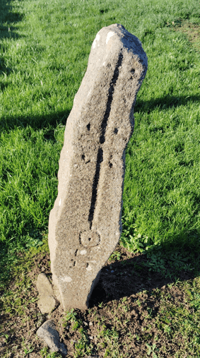
Riasc Cross Inscribed Stone Detail
Riasc is particularly important because much of the settlement was systematically excavated. Archaeologist Thomas Fanning directed excavations for the Office of Public Works between 1972 and 1975, exposing the enclosure, buildings, cemetery and areas associated with craft and domestic activity.
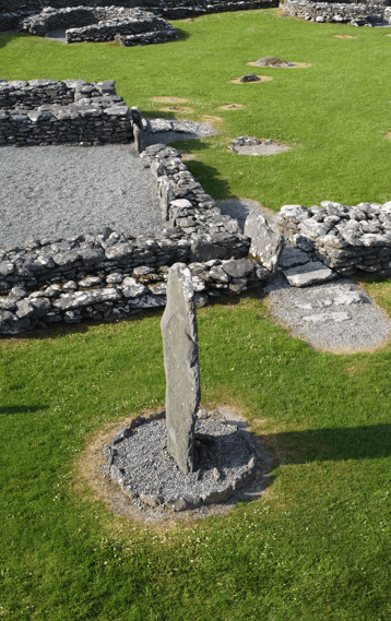
Riasc Pillar Stone and Settlement
The excavation revealed a complex sequence rather than a settlement belonging to a single moment in time. Nearly forty long lintel graves formed the primary cemetery. Stratigraphic evidence — the archaeological relationship between features — demonstrated that some of these graves existed before the small stone oratory was constructed. Smaller box-like graves were added after the oratory had fallen out of use.
A paved setting enclosed by upright slabs was also discovered within the cemetery. Fanning interpreted this as a possible slab-shrine and suggested that it may have formed an early focus for burial. Its precise purpose cannot be proven, however, so the shrine interpretation remains a reasoned archaeological interpretation.
Artefacts provide further evidence for life at Riasc. Finds included cross-inscribed stones, glass beads, spindle whorls, rotary querns, handmade and imported pottery, crucible fragments, iron slag and a small stone figurine. Furnace remains provide strong evidence for high-temperature craft activity, including ironworking.
Among the most significant discoveries were fragments of imported wheel-made pottery identified as B-ware amphorae. These vessels are associated with commodities reaching Atlantic Britain and Ireland through long-distance exchange networks during the later fifth to seventh centuries. Their presence demonstrates that Riasc participated in these wider networks, although it does not indicate direct contact between the settlement and the Mediterranean.
Poor preservation of human remains limits what archaeology can tell us about the people buried at Riasc. Nevertheless, the excavation provides unusually detailed evidence for the organisation and changing use of a small early medieval ecclesiastical settlement.
Fragments of imported amphorae found at Riasc place the settlement within long-distance exchange networks linking western Ireland with Britain and the wider Mediterranean trading world during the later fifth to seventh centuries.
Archaeological evidence from Riasc shows that everyday activity extended well beyond worship. The people using the settlement processed food, worked with metal and produced textiles within the same enclosed community that contained its religious and burial areas.
Rotary querns, used for grinding grain, and a grain-drying kiln provide evidence for cereal processing. These finds indicate that preparing and processing agricultural produce formed part of everyday activity at the settlement.
Craft production was also important. Archaeologists discovered iron slag, furnace bottoms and furnace pits associated with ironworking. One furnace contained clay lining, charcoal fuel, crucible fragments and possible pieces of a tuyère — a ceramic fitting used to direct air into a high-temperature fire. Crucible fragments may also indicate work with non-ferrous metals, although the precise processes undertaken at Riasc have not been established.
Spindle whorls provide evidence for textile production, while glass beads and imported glass demonstrate access to specialist materials. Evidence for actual glass manufacture at Riasc is less certain and should not be assumed from these finds alone.
Food remains add another dimension. Limpet shells and animal bone indicate that both marine and terrestrial food resources were exploited, while peat charcoal shows the use of locally available fuel.
Together, these discoveries reveal Riasc as a working community where religious activity existed alongside food preparation, craft production and other practical tasks. The evidence allows these activities to be identified, although it cannot tell us precisely who performed them or how everyday responsibilities were organised.
The combination of furnaces, querns, a grain-drying kiln and spindle whorls demonstrates that metalworking, cereal processing and textile production all took place within Riasc’s ecclesiastical enclosure.
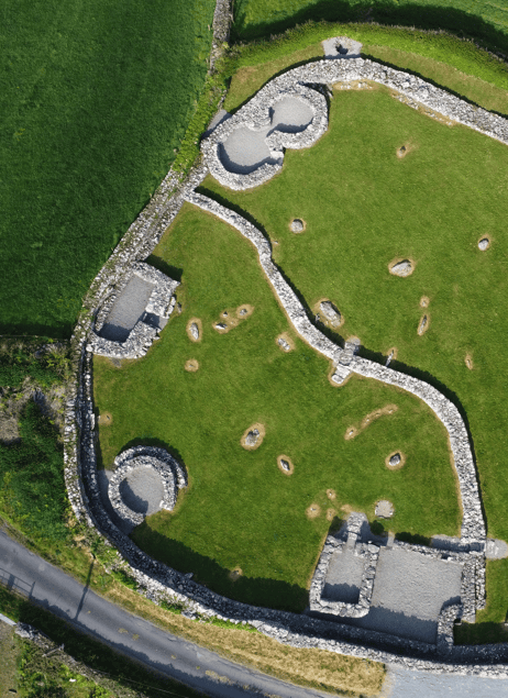
Riasc Monastic Settlement Overhead View
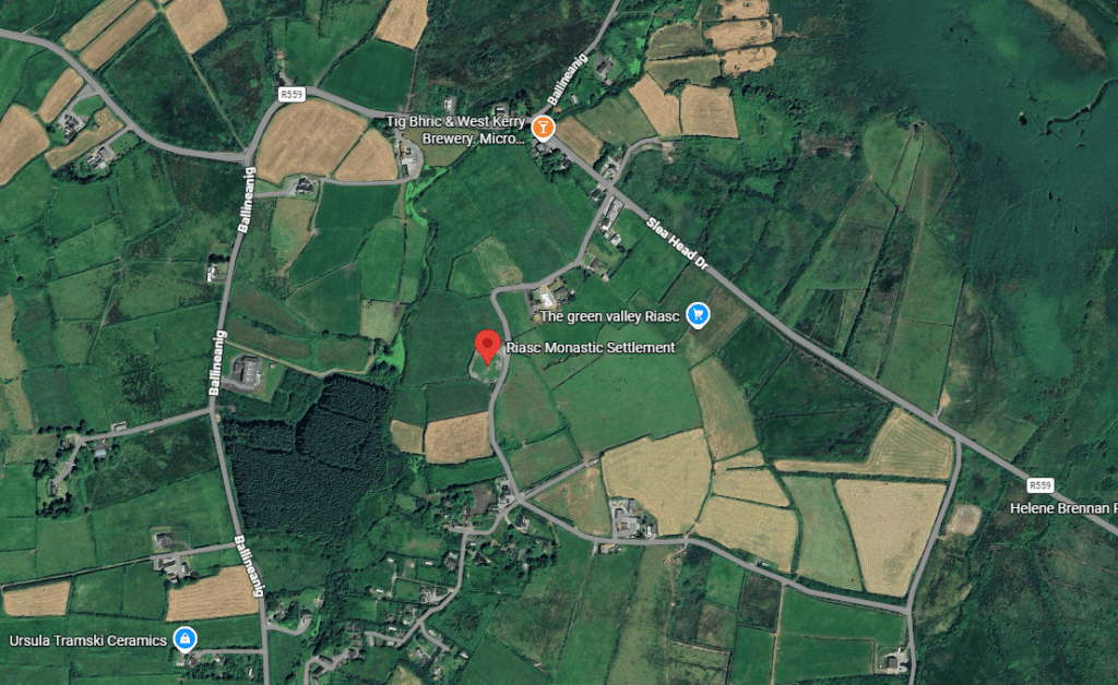
Riasc lies in the western Dingle Peninsula, approximately 1.5 kilometres east of Ballyferriter, within a landscape characterised by low coastal ground, small streams and naturally wet soils. The Irish placename An Riasc has been associated with marshy or boggy ground, reflecting the character of the surrounding landscape.
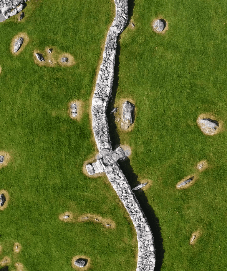
Riasc Internal Enclosure Wall
The location gave the community access to a range of useful local resources. Agricultural land supported food production, while peat provided fuel and locally available stone supplied the principal material for buildings, graves and enclosure walls. Limpet shells recovered during excavation also demonstrate the use of nearby marine resources.
Riasc was not an isolated religious settlement. It formed part of a wider concentration of early medieval ecclesiastical and secular sites across Corca Dhuibhne, the Dingle Peninsula. Nearby ecclesiastical sites include Gallarus, Kilmalkedar and Ballywiheen, while clocháns and ringforts elsewhere in the western peninsula provide comparisons for its dry-stone architecture and settlement traditions.
Its Atlantic-facing position is particularly significant when considered alongside the imported pottery discovered during excavation. These finds show that the community participated in wider exchange networks connecting western Ireland with Britain and more distant trading systems.
The surviving evidence therefore places Riasc within both a local landscape of farming, natural resources and neighbouring settlements and a much broader early medieval network of communication and exchange.
Riasc was one of several ecclesiastical settlements in Corca Dhuibhne. Nearby sites including Gallarus and Kilmalkedar show that early Christian communities formed an important part of the western Dingle Peninsula’s historic landscape.
Follow the development of Riasc from its early medieval beginnings through burial, settlement activity, later reuse and archaeological excavation. Some phases cannot be dated precisely, so the timeline reflects the strongest available archaeological evidence rather than assigning exact dates where none are known.
Imported amphora pottery provides evidence for early activity at Riasc and participation in long-distance exchange networks.
The stone enclosure, clocháns, craft areas and primary burial focus formed part of a working ecclesiastical community.
Nearly forty lintel graves were established, with the small stone oratory constructed after some of the earlier burials.
Smaller stone-set graves were inserted after the oratory had fallen out of use, showing continued funerary use of the site.
Riasc remained in local memory as a ceallúnach, a burial ground associated with those buried outside ordinary consecrated graveyards.
Thomas Fanning directed the Office of Public Works excavation that revealed the settlement’s buildings, burials and activity areas.
Fanning’s full excavation report was published in the Proceedings of the Royal Irish Academy.
Everything you need to know before visiting Riasc Monastic Settlement, including parking, access, admission, facilities and practical information to help you make the most of your visit.
Approximately 1.5 km east of Ballyferriter, approached by narrow local roads.
Free parking is available beside the Office of Public Works right of way (limited spaces).
Unguided public access; open archaeological remains with low walls and uneven ground.
Admission is free
Daylight hours in good weather
Gallarus ecclesiastical complex, Kilmalkedar ecclesiastical site and Ballywiheen monastic site.
Explore more historic places, monuments and archaeological sites across County Kerry.
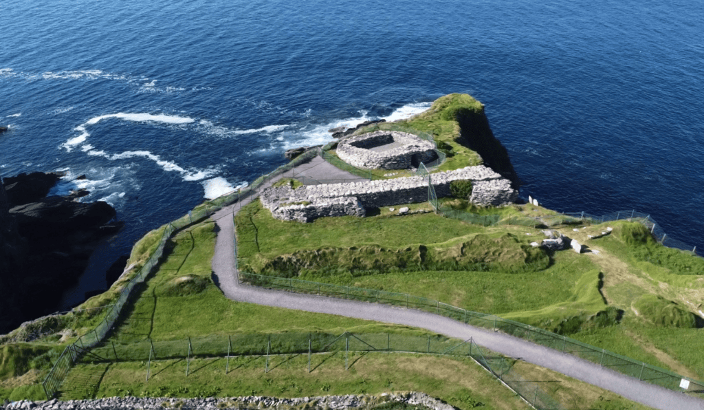
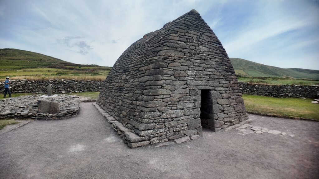
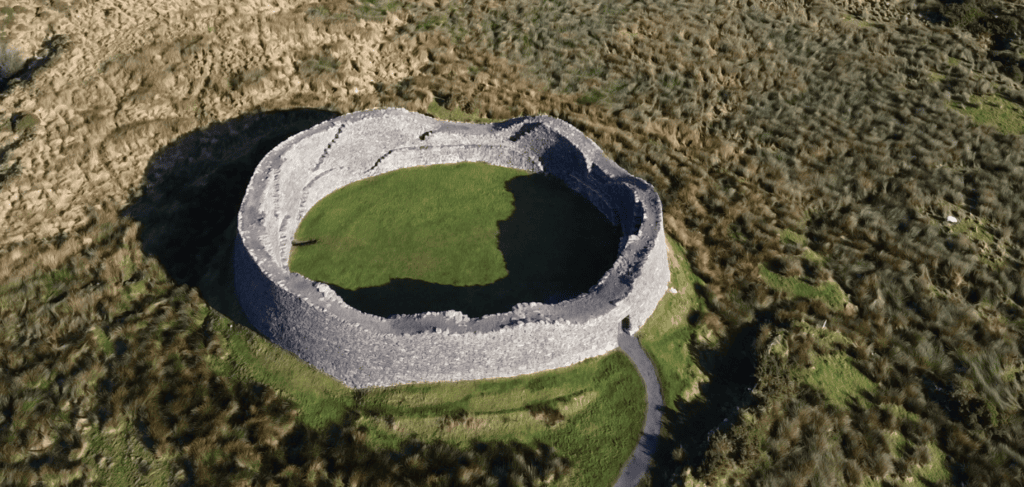
Reading about Riasc provides the archaeological background, but visiting the site helps bring its unusual layout into focus. Walking through the enclosure, you can begin to understand how worship, burial, domestic life and craft activity existed together within this small early medieval community. With your guide, the surviving foundations can be interpreted in the context of the excavations, from the clocháns and small oratory to the cemetery and areas associated with everyday work. Riasc also provides an excellent introduction to the wider early Christian landscape of Corca Dhuibhne and a natural starting point for continuing to explore Kerry’s history.
If you would rather leave the driving behind, I offer private tours across the Dingle Peninsula and County Kerry. Each experience is designed for small private groups, with a relaxed pace, local knowledge and the flexibility to spend more time at the places that interest you most.
A relaxed three-hour private tour around Slea Head and the spectacular western coastline of the Dingle Peninsula.
Explore Slea Head, ancient heritage sites, coastal viewpoints and the landscapes of West Kerry on a private half-day experience.
Discover more of the Dingle Peninsula with a full day to explore its scenery, history, villages and lesser-known places.
Journey around the Iveragh Peninsula, combining the Ring of Kerry with the dramatic landscapes and Atlantic coastline of the Skellig Ring.
Explore Killarney National Park, its lakes, mountain viewpoints, waterfalls and some of the most beautiful landscapes in County Kerry.
Travel north from Kerry for a private day tour through the Burren to the spectacular Cliffs of Moher on Ireland’s Atlantic coast.
Create a private Kerry itinerary around the places, landscapes and experiences that matter most to you.
The information presented on this page is based on archaeological research, official heritage records and published academic studies. Where archaeological evidence is incomplete, uncertainty has been stated rather than resolved through assumption. This approach reflects the editorial standards used throughout the Steve’s Peninsula Tours History Collection.
Fanning, T. (1981). “Excavation of an Early Christian Cemetery and Settlement at Reask, County Kerry.” Proceedings of the Royal Irish Academy, Section C, 81, 67–172.
Fanning, T. (1972, 1973 & 1975). “Reask, Kerry.” Excavation summaries, National Parks and Monuments Branch, Office of Public Works.
Office of Public Works / Heritage Ireland. “Reask Ecclesiastical Site.” Official state-care monument information.
Placenames Database of Ireland / Logainm.ie. “An Riasc / Reask.” Validated Irish placename and archival records.
Cuppage, J. (1986). Archaeological Survey of the Dingle Peninsula / Suirbhé Seandálaíochta Chorca Dhuibhne. Ballyferriter: Oidhreacht Chorca Dhuibhne.
Ó Carragáin, T. (2010). Churches in Early Medieval Ireland: Architecture, Ritual and Memory. Yale University Press.
Edwards, N. (1990). The Archaeology of Early Medieval Ireland. Batsford.
Mytum, H. (1992). The Origins of Early Christian Ireland. Routledge.
Loading availability…