
HISTORY COLLECTION
Garfinny Bridge is a historic single-span stone arch bridge crossing the Garfinny River around 2.5–3 km north-east of Dingle on the Dingle Peninsula. Protected as a National Monument in State guardianship, it is recognised as one of Ireland’s most distinctive surviving vernacular stone bridges.
Medieval (probable)
14th–15th century
Garfinny,
County Kerry
Single-span
Stone Arch Bridge
Unguided Site
Pedestrian Access Only
Garfinny Bridge rewards close observation of its remarkable stone construction and peaceful river setting. The bridge’s distinctive pointed arch, corbelled stone supports and dry-stone masonry illustrate traditional building techniques that have survived despite centuries of use, repair and restoration. The surrounding landscape also helps place the bridge within the historic route network east of Dingle.
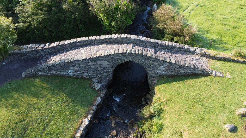
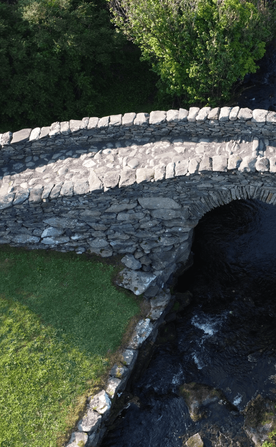
The slightly pointed stone arch rests on distinctive corbelled supports above the Garfinny River.
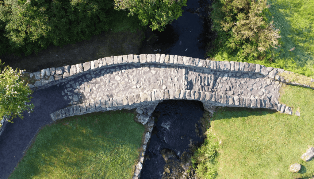
Traditional dry-laid stone paving and low parapet walls showcase the craftsmanship of this historic crossing.
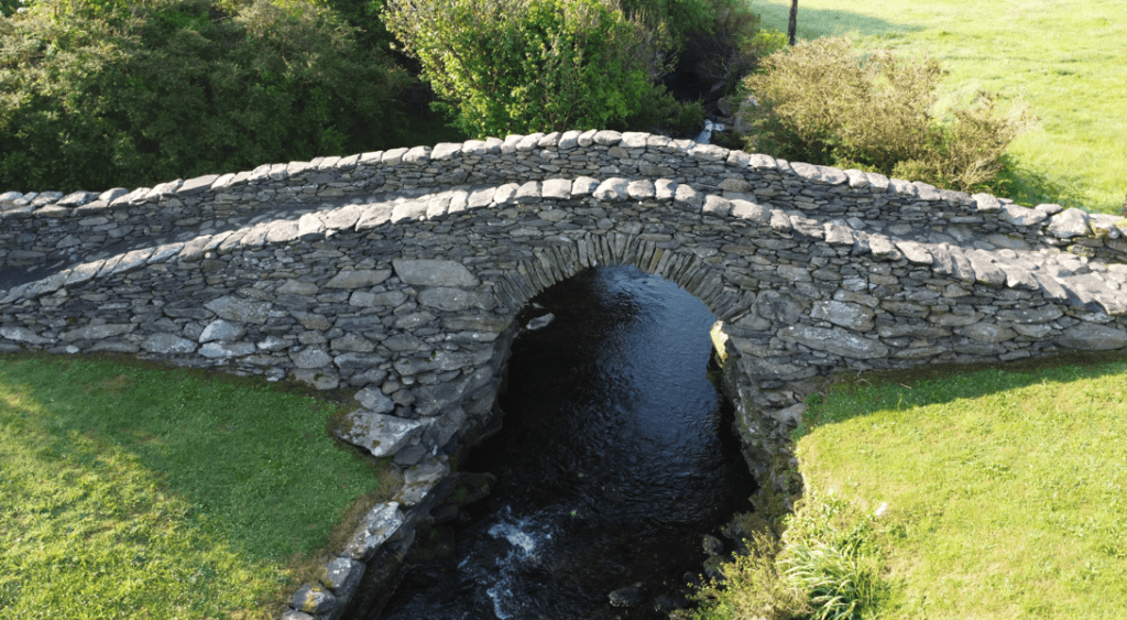
Viewed from above, the elegant single-span arch illustrates the bridge’s remarkably well-preserved vernacular stone construction.
Every historic site has a unique story shaped by its landscape, history and surviving remains. This section provides the key facts you need to understand the monument, including its location, historical importance and defining features, offering a solid foundation before exploring the site in greater depth.
Irish name
Droichead na Gairfeanaí
County
Kerry
Monument Type
Single-span Stone Arch Bridge
National Monument Number
66
Historical Period
Medieval
Ownership
National Monument in State guardianship
Date
Probably 14th–15th century
Condition
Restored and maintained
Townland
Garfinny and Flemingstown
Archaeological Investigation
NA
Civil Parish
Garfinny (An Ghairfeanaigh)
Public Access
Unguided pedestrian access
Latitude
52.149960
Longitude
-10.226822
Addresss
Garfinny, Co. Kerry
Nearest Town
Dingle
Road access
Off N86
Garfinny Bridge has served as a crossing over the Garfinny River for centuries, although the history of the crossing itself may be older than the surviving bridge. Official interpretation identifies the monument as probably dating from the fourteenth or fifteenth century, but no scientific dating or archaeological excavation has confirmed when the standing structure was built. The bridge may therefore preserve the alignment and form of an earlier crossing while incorporating later rebuilding.
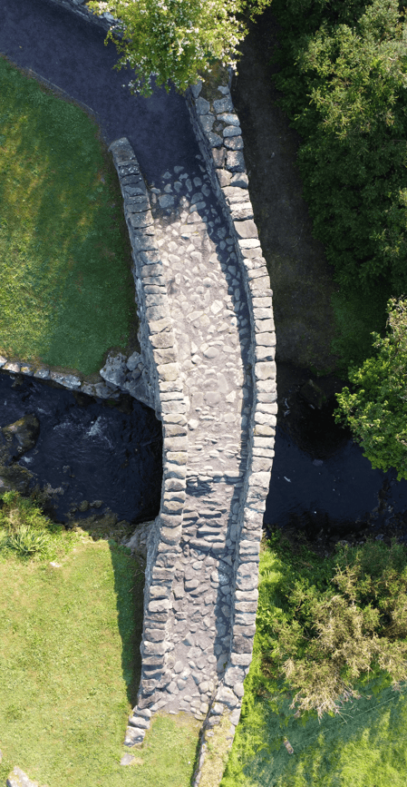
Garfinny Bridge Overhead View
By the early nineteenth century, Garfinny Bridge was already recognised as an historic monument. During a visit in 1838, the traveller Georgiana Chatterton described leaving the main road and following a narrow rocky track to reach what she considered an antiquity. Her account provides the earliest securely documented evidence that the bridge was valued for its historical significance rather than simply its practical use.
As traffic increased during the nineteenth century, the narrow bridge became less suitable for everyday transport. Official accounts state that deterioration, combined with growing traffic demands, eventually led to the construction of a newer bridge a short distance upstream. Garfinny Bridge was later restored and today survives as a protected National Monument in State guardianship, preserved as a historic monument rather than as part of the modern road network.
One aspect of the bridge’s history remains uncertain. While official interpretation suggests a medieval origin, bridge historians have proposed that much of the visible stonework may result from substantial nineteenth-century rebuilding, possibly preserving an earlier bridge beneath or within the present structure. Because no published excavation or detailed fabric analysis has been undertaken, this interpretation remains unresolved.
The bridge’s history and its surviving stonework are not necessarily the same. Current research distinguishes between the history of the river crossing, the age of the visible masonry and the bridge’s later restoration, meaning its exact construction history remains an open archaeological question.
Garfinny Bridge is a compact single-span stone arch bridge built using locally available stone and traditional dry-stone construction techniques. The bridge is approximately 16 metres long and between 2 and 2.5 metres wide, with a steeply humped deck that rises around 3 metres above the river. Its narrow proportions reflect a crossing designed for pedestrians, pack animals and light pre-modern traffic rather than modern vehicles.
The bridge’s most distinctive architectural feature is its slightly pointed, stilted arch. Rather than springing directly from vertical supports, the arch begins on projecting corbelled stones known as imposts. Above these, thin wedge-shaped stones called voussoirs form the true arch, distributing weight through compression into the bridge’s abutments. This combination of corbelling and arch construction is unusual and demonstrates a practical engineering solution using irregular stone.
The bridge deck is surfaced with large dry-laid stone slabs and bordered by low dry-stone parapet walls. Rubble masonry forms the spandrels and approach walls, while the bridge itself was constructed without lime mortar according to official interpretation. Some historic descriptions also mention clay or earth packing within the structure, although no scientific analysis has been carried out to confirm how these materials were used.
Although the bridge retains its historic character, the present appearance may represent several phases of repair and rebuilding. Differences in the masonry suggest later interventions, but without a detailed stone-by-stone survey it is not possible to determine which parts of the structure are original and which belong to later restoration.
Garfinny Bridge combines two construction techniques in a single structure. The bridge uses projecting corbelled stones to support a true stone arch built from radial voussoirs, creating an efficient design that required only minimally worked local stone.
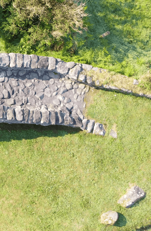
Garfinny Bridge Stone Paving Detail
Unlike many historic monuments, Garfinny Bridge has never been the subject of a published archaeological excavation. As a result, there is no stratified archaeological record, no recovered artefacts and no scientific dating evidence that can confirm when the bridge was first built or identify the sequence of later repairs. This absence of excavation is one of the main reasons why aspects of the bridge’s history remain uncertain.
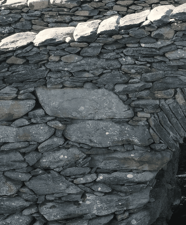
Bridge’s dry-laid stone masonry
Most of what is known today comes from careful study of the bridge itself rather than excavation. Archaeologists and architectural historians examine features such as the shape of the arch, the arrangement of the stonework and the construction techniques to understand how the bridge was built. They also compare Garfinny Bridge with other historic Irish stone bridges and consult historical documents to place it within a wider context.
The bridge is protected as a National Monument in State guardianship and forms part of Ireland’s national archaeological record. Modern research has also highlighted an important debate over the age of the visible stonework. While official interpretation considers the bridge to be of probable fourteenth- or fifteenth-century origin, some bridge historians argue that much of the surviving masonry may reflect extensive nineteenth-century rebuilding while preserving an earlier bridge beneath or within the present structure. Without scientific investigation, neither interpretation can be confirmed.
Future research could answer many of these questions. The dossier recommends detailed laser scanning, stone-by-stone recording, geological analysis, archival research and carefully targeted archaeological investigation where conservation work makes this possible. Together, these techniques could help establish the bridge’s construction sequence while preserving the monument for future generations.
Garfinny Bridge is understood primarily through observation rather than excavation. Its construction methods, architecture and historical records provide most of the available evidence, while the exact age of much of the visible masonry remains an unresolved question awaiting future archaeological and scientific study.
For centuries, Garfinny Bridge provided a practical route across the Garfinny River for local communities travelling between Dingle and the eastern hinterland of the peninsula. Its narrow width and steeply humped profile indicate that it was intended for pedestrians, pack animals and lightly loaded carts rather than large vehicles. The bridge formed part of an everyday transport network that connected farms, settlements and neighbouring parishes.
Although no archaeological excavation has taken place, the bridge itself provides valuable evidence for how it was used. The large stone paving slabs, low parapet walls and compact design suggest a crossing built for regular local travel rather than heavy commercial traffic. As roads improved during the nineteenth century and traffic increased, the historic bridge became less practical and was eventually replaced by a modern crossing upstream.
The bridge may also have witnessed important historical events. Local tradition claims that Arthur Grey and an English force crossed here on their way to the Smerwick campaign in 1580. While this route is geographically possible, no contemporary evidence confirms that Garfinny Bridge was the crossing point. This tradition therefore remains part of the area’s local heritage rather than established historical fact.
Today, the bridge offers an insight into the rhythms of everyday life before modern roads. Rather than being remembered for a single historic event, its greatest significance lies in centuries of continuous local use, linking people, communities and the surrounding landscape.
The bridge’s greatest legacy is its everyday role. For generations it enabled ordinary journeys across the Garfinny River, long before modern roads transformed travel across the Dingle Peninsula.
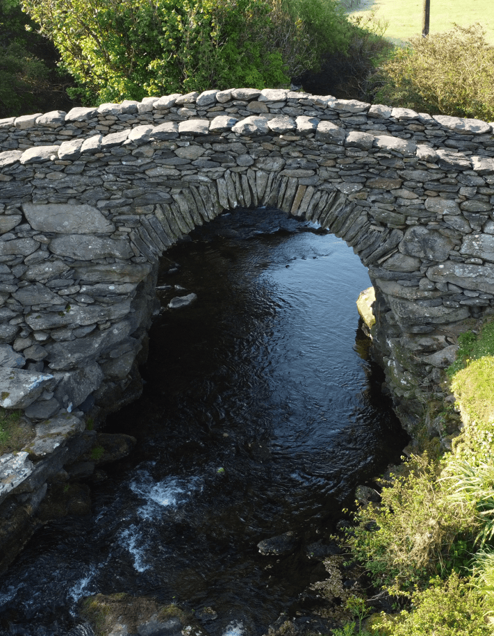
Garfinny Bridge Stone Arch
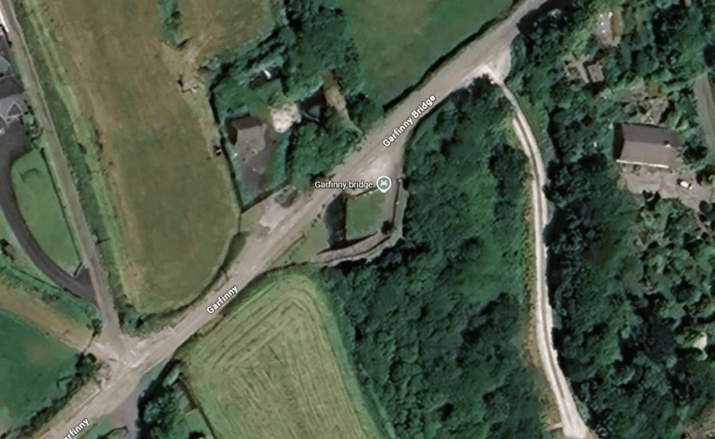
Garfinny Bridge stands on the Garfinny River approximately 2.5–3 km north-east of Dingle, within the historic parish of Garfinny on the southern slopes of the Dingle Peninsula. The bridge occupies a natural crossing point where a mountain-fed river cuts through the landscape before flowing towards Dingle Bay. Its location reflects the practical need to maintain an east–west route across the river long before modern road engineering transformed the area.
Garfinny Bridge Aerial Detail
The surrounding landscape has played an important role in shaping the bridge’s history. Seasonal rainfall from the peninsula’s uplands creates fast-flowing water capable of causing erosion around the bridge’s foundations, making careful construction and ongoing maintenance essential. Even today, the nearby modern bridge continues the same crossing route, demonstrating that this location has remained important for local travel over many centuries.
Garfinny Bridge forms part of one of Ireland’s richest historic landscapes. Nearby monuments include Garfinny Church and graveyard, the Ballintaggart ogham stones, Kilmalkedar Church, Gallarus Oratory, Gallarus Castle, Rahinnane Castle and the wider Smerwick landscape. Together these sites reflect thousands of years of settlement and movement across the Dingle Peninsula, although no direct functional relationship between each monument and the bridge has been established.
Today the bridge is best understood as one element within this wider cultural landscape. Rather than standing in isolation, it preserves part of a historic route network that connected communities, farms, places of worship and coastal settlements long before modern roads altered the way people travelled across west Kerry.
Garfinny Bridge is significant not only for its architecture but also for its location. The crossing has remained important for centuries, with today’s modern bridge continuing the same route across the Garfinny River while the historic bridge survives as a protected monument.
Explore the history of this remarkable site through the centuries, from its earliest origins and changing role over time to archaeological investigation and modern conservation. While some dates remain approximate, this timeline is based on the best available archaeological evidence, historical records and current research, helping place the monument within its wider historical context.
Official interpretation suggests Garfinny Bridge was built during the fourteenth or fifteenth century, although no scientific dating has confirmed its age.
If local tradition preserves a genuine route memory, a bridge or earlier crossing may already have existed before the Smerwick campaign. This remains a hypothesis rather than an established fact.
Local tradition claims Arthur Grey and approximately 800 English troops crossed Garfinny Bridge on their way to Dún an Óir. No contemporary evidence confirms the crossing.
Traveller Georgiana Chatterton visited Garfinny Bridge, describing it as an antiquity reached by a narrow rocky track, providing the earliest documented account of the bridge as a place of historical interest.
As traffic increased and the historic bridge deteriorated, a newer bridge was constructed upstream, ending Garfinny Bridge’s role as the area’s main river crossing.
Garfinny Bridge was restored and is now preserved as a National Monument in State guardianship, protecting the historic crossing for future generations.
Everything you need to know before visiting Dunbeg Fort, including parking, access, admission, facilities and practical information to help you make the most of your visit.
Approximately 2.5–3 km north-east of Dingle, crossing the Garfinny River on the Dingle Peninsula.
Visitor parking is available near the entrance.
Unguided pedestrian access across the historic bridge. The uneven stone surface and low parapet walls require care.
Free
Daylight hours when conditions are dry. Wet weather and high river levels can make the historic stone surface more hazardous.
Garfinny Church and Graveyard, Ballintaggart Ogham Stones, Kilmalkedar Church, Gallarus Oratory, Gallarus Castle and Rahinnane Castle.
Explore more historic places, monuments and archaeological sites across County Kerry.
Reading about this remarkable place is only the beginning. Experience its landscape, uncover the stories behind its history, and see the archaeological evidence in context with a private guided tour. Discover how each location fits into the wider story of the Dingle Peninsula and County Kerry through local knowledge, history and unforgettable scenery.
The information presented on this page is based on archaeological research, official heritage records and published academic studies. Where archaeological evidence is incomplete, uncertainty has been stated rather than resolved through assumption. This approach reflects the editorial standards used throughout the Steve’s Peninsula Tours History Collection.
Office of Public Works (OPW) / Heritage Ireland – Garfinny Bridge
National Monuments Service – Monuments in State Care: County Kerry
Placenames Database of Ireland (Logainm.ie)
Georgiana Chatterton – Rambles in the South of Ireland During the Year 1838 (1839)
Peter O’Keeffe & Tom Simington – Irish Stone Bridges: History and Heritage (1991)
Tom Ruddock – The Old Bridges of Munster (2019)
Geological Survey Ireland – Geology of the Dingle Peninsula: A Field Guide
Laurence Dunne – Archaeological Survey, Garfinny, Dingle, County Kerry (2020)
Loading availability…